|
||

|

|
|

|
The Exceedingly Rare First State.
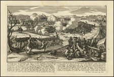
William Faden's 1777 map, "The British Colonies in North America," provides a revealing and historically significant depiction of Great Britain's American colonies at a time when the Revolutionary War was still underway. Encompassing territory from the northern reaches of Newfoundland to the southern tip of Florida and extending westward beyond the Mississippi, the map presents a comprehensive and updated view of the contested lands.
The map draws inspiration from John Mitchell’s renowned "Map of the British and French Dominions in North America," first published in 1755 and subsequently reprinted by Faden. Yet, despite the shared origins, Faden's rendition exhibits numerous adaptations and refinements, which transform an eight-sheet map into a single, highly informative sheet. Notably, enhancements can be seen in the representation of regions like the coast north from the Carolina banks, Nova Scotia and Newfoundland, Lake Champlain, and James Bay. The inclusion of the whole Florida peninsula and the provinces of "East Florida" and "West Florida," both established in 1763, also marks a significant update.
A fresh cartouche features prominently on Faden's map. This element illustrates America as a largely untamed expanse, populated by rugged cliffs, abundant palm trees, and an isolated plantation. A scene depicting a captain or merchant negotiating with two dark-skinned figures over barrels and bales subtly conveys Great Britain's imperialist and mercantilist perspective of the colonies—viewing them as primitive, subordinate, and primarily useful for the raw materials they could provide for Britain's burgeoning industrial economy.
The map's title, "The British Colonies in North America," can be perceived as an act of "cartographical denial." Released after the Declaration of Independence, the very concept of "British Colonies"—barring Canada and Florida—was already outdated, reflecting the reluctance of many in the mother country to accept the reality of American independence. This artifact thus stands as a significant piece of historical cartography, encapsulating the geopolitical dynamics and tensions of its time.
This map serves as a valuable document that illuminates the governmental decisions made by the British Parliament, which were instrumental in triggering the Revolutionary War. One such decision, the Quebec Act of 1774, not only expanded the boundaries of the Quebec province but also allowed Canadian Catholics freedom of worship and the right to hold public office. This move, primarily intended to secure the loyalty of the predominantly French-Catholic population in Canada and to limit the westward expansion of American colonists, stirred significant discontent among the colonies.
The Quebec Act's adjustments greatly agitated several East Coast colonies. New York, Pennsylvania, and Virginia, citing their original Crown charters, staked claims to the territory north and west of the Ohio. The expanded Quebec region was also coveted by aspiring settlers and land speculators, including prominent figures like George Washington. Adding to the turmoil was the perception among American colonists that the Act sought to extend Catholicism across the British colonies—a provocative move, considering many settlers had sought refuge in the Americas to escape state-enforced religion.
The reasons behind the American Revolution are complex and multifaceted, encompassing cultural, economic, legal, and philosophical aspects. Nonetheless, the Quebec Act, with its controversial alterations to territory and religious tolerance, undeniably added to the boiling pot of American grievances. This sentiment is explicitly reflected in the Declaration of Independence, which mentions the Act in its list of "repeated injuries and usurpations" as an example of the abolition of the English legal system and the expansion of an arbitrary government in neighboring provinces. By extension, Faden's map, published in the midst of these historical events, becomes a significant cartographic artifact, highlighting the tensions and disputes that led to the shaping of a new nation.
Rarity
This is the first of at least fifteen states. In the second state, the title would be reengraved to refer to the United States.
We have not seen a copy for sale on the market in 20 years.
William Faden (1749-1836) was the most prominent London mapmaker and publisher of the late-eighteenth and early-nineteenth centuries. His father, William Mackfaden, was a printer who dropped the first part of his last name due to the Jacobite rising of 1745.
Apprenticed to an engraver in the Clothworkers' Company, he was made free of the Company in August of 1771. He entered into a partnership with the family of Thomas Jeffreys, a prolific and well-respected mapmaker who had recently died in 1771. This partnership lasted until 1776.
Also in 1776, Faden joined the Society of Civil Engineers, which later changed its name to the Smeatonian Society of Civil Engineers. The Smeatonians operated as an elite, yet practical, dining club and his membership led Faden to several engineering publications, including canal plans and plans of other new engineering projects.
Faden's star rose during the American Revolution, when he produced popular maps and atlases focused on the American colonies and the battles that raged within them. In 1783, just as the war ended, Faden inherited his father's estate, allowing him to fully control his business and expand it; in the same year he gained the title "Geographer in Ordinary to his Majesty."
Faden also commanded a large stock of British county maps, which made him attractive as a partner to the Ordnance Survey; he published the first Ordnance map in 1801, a map of Kent. The Admiralty also admired his work and acquired some of his plates which were re-issued as official naval charts.
Faden was renowned for his ingenuity as well as his business acumen. In 1796 he was awarded a gold medal by the Society of Arts. With his brother-in-law, the astronomer and painter John Russell, he created the first extant lunar globe.
After retiring in 1823 the lucrative business passed to James Wyld, a former apprentice. He died in Shepperton in 1826, leaving a large estate.

![A New and Exact Map of the Dominions of the King of Great Britain on ye Continent of North America . . . [Beaver map]](https://storage.googleapis.com/raremaps/img/small/101277.jpg)
![(Anti-Nato Propaganda) Военные Блоки-Оплот Милитаризма [Military Blocs-Strongholds of Imperialism]](https://storage.googleapis.com/raremaps/img/small/94274.jpg)
![Map of the United States And Territories, Together with Canada &c. [Shows Massive Idaho Territory]](https://storage.googleapis.com/raremaps/img/small/100353.jpg)