|
||

|

|
|

|
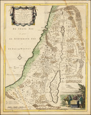
Judaea seu Terra Sancta Quae Hebraeorum sive Israelitarum in suas duodecim Tribus divisa secretis ab invicem Regnis Iuda et Israel expressis insuper sex ultimi temporis ejusdem Terrae Provincijs . . . is a finely engraved map of the Holy Land by Peter Schenk, created in Amsterdam in 1695.
The map notably depicts the division of the Holy Land into the Twelve Tribes of Israel. On the west side of the Jordan River, the map illustrates the tribes of Judah, Benjamin, Simeon, Dan, Ephraim, half of Manasseh, Issachar, Zebulun, Naphtali, and Asher. Meanwhile, on the east side of the river, it shows the tribes of Reuben, Gad, and the other half of Manasseh.
The map also separates and depicts the kingdoms of Judah and Israel, providing a comprehensive picture of the political landscape of the region during biblical times.
Furthermore, it highlights the six provinces of the same land during its later periods, adding another layer of historical insight.
One of the distinctive features of the map is the finely engraved allegorical cartouche that adds artistic value to this historical document. The cartouche, like the map itself, is reflective of the craftsmanship and attention to detail characteristic of Peter Schenk's work.
Peter Schenk the Elder (1660-1711) moved to Amsterdam in 1675 and began to learn the art of mezzotint. In 1694 he bought some of the copperplate stock of the mapmaker Johannes Janssonius, which allowed him to specialize in the engraving and printing of maps and prints. He split his time between his Amsterdam shop and Leipzig and also sold a considerable volume of materials to London.
Peter Schenk the Elder had three sons. Peter the Younger carried on his father’s business in Leipzig while the other two, Leonard and Jan, worked in Amsterdam. Leonard engraved several maps and also carried on his father’s relationship with engraving plates for the Amsterdam edition of the Histoire de l'Académie Royale des Sciences.
![(Nuremberg Chronicle) [Saul and Odysseus]](https://storage.googleapis.com/raremaps/img/small/98684.jpg)
![[ Cyprus, Syria, Palestine, etc. ]](https://storage.googleapis.com/raremaps/img/small/103027.jpg)