


|
||

|

|
|

|
Modified By An Early Owner To Show The Discoveries of Le Maire and Schouten
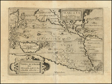
Rare separately published example of the third edition of Ortelius's map of America, with no printed text on the verso, with contemporary changes in manuscript to the front of the map, almost certainly made by an early owner.
The map is extraordinary artifact, containing both hand drawn geographical changes on the front of the map and handwritten text annotations on the verso. The changes to the front include careful removal of a portion the printed image near the Straits of Magellan, in order to draw in the recent discoveries of the Le Maire Strait, which had been discovered in a voyage of 1615-1616 by Jacob Le Maire and Willem Schoten. This discovery actively suppressed for several years (see below).
At the bottom of the map, below the Straits of Magellan, an early owner of the map has abraided (ie scratched away), several sections of the southern continent, in order to convert Terra Del Fuego into an island, then added hachuring and stippling to show a southern coastline and open sea below (illustrating the Strait discovered by Le Maire). Similarly, further east, in the same hand, the coast of the Southern continent has been modified to suggest an open sea below Ortelius's name and the 1587 engraving date. This work has been done by what appears to be the same ink (and same hand), as the annotations on the verso. The verso text is titled Miscellanea America and numbered page 127.
While the vast majority of Ortelius maps have printed text on the verso and were bound into editions of this Theatrum Orbis Terrarum published between 1570 and 1612, it is well documented that his maps were also sold separately, without text on the verso, and that such sales continued for at least 30 years after 1612. Moreover, sometime after 1616, some of the printed maps were re-engraved or modified to include revised geographical features, including Ortelius's map of America, which was likely revised between 1618 and 1630.
As noted by Gunter Schilder, Monumenta Cartographica Neerlandica, Volume III, page 256:
. . . for a long time it was supposed that the history of this atlas of the world ended with the Spanish edition of 1612, and that the copperplates were not used any more. . .
From archive material we know that in 1618 Balthasar Moretus made preparations for a reissue of the Theatrum: he paid rather high sums to engravers Ferdinand Arsenius and Arnold Floris van Langren for the adaptation of the copperplates. The mathematician Godefridus Vendelinus was to write an explanatory text. For reasons unknown this project was shelved. However, the recent discovery of a complete copy of the atlas provides that, in spite of this, an atlas of the world appeared in the forties [1640s], in which the plates were printed on the old Spanish text sheets of 1612. Both on the map of the world by Ortelius and on the one of America the representation of the big, unknown Southland ('Terra Avstralis nondvm cognita', 'Terra Avstralis, sive Magellanica hactenvs incognita', respectively) in the region of South America is interrupted and completed with the discoveries made during the voyage of Le Maire. . .
As such, it would seem most likely that the present map was prepared sometime between 1617 and the re-engraving of the map of America for Balthasar Moretus.
The Suppression of the Discovery of the Le Maire Strait
The confluence of a separately published example of Ortelius's map of America and the act by an early owners of scratching away a portion of the surface of the map in order to add the discovery of the Strait is quite intriguing. From the text on the verso, we can see that the early owner was interested in early navigation, with discussions of Magellan, Brazil and Canada in the text.
At the more or less the same time, the Dutch East India Company (VOC) was actively working to suppress Le Maire's discoveries. Le Maire and Schouten's voyage had been sponsored by a group of Dutch merchants who were not part of the VOC. The discovery of the Strait was deemed to threaten the VOC's monopoly. After Jacob Le Maire had discovered the Strait and was anchored in Batavia, the local VOC authorities recognized the threat to VOC domination of the trading route, imprisoning the crew and confiscating all the documents on board Le Maire's ships. On July 29, 1617, Willem Jansz Blaeu was banned from publishing news or maps relating to the discoveries made by the Le Maire voyage. Blaeu, the official VOC cartographer had received the documents seized in Batavia. A further edict was made on August 2, 1617, which forbade Blaeu from making corrections to the existing globe or maps to include the discovery:
It is resolved thereupon to notify the aforesaid Willem Jansz., that he shall not presume to correct the Globe, or the printed or written Map, nor in any other manner to publish or cause to be published the aforesaid discover[ies] . . .
The ban lasted until August 1618, when it was lifted by the VOC, which recognized the futility of trying to permanently suppress the discovery, with Blaeu publishing an account of the voyage in 1618, but virtually omiting any mention of Le Maire by name.
The lack of any mention of Le Maire's name on the present Ortelius map, either on the front or in the text on the verso, strongly suggests that the annotations were created in the short window of time either during the ban or shortly thereafter.
Coincidental Timing?
As noted above, Balthasar Moretus, then head of the Plantijn publishing firm, was in the process of preparing changes for a new edition of the Ortelius Theatrum Orbis Terrarum. August 1618 is also the date when the edict barring Blaeu from depicting Le Maire's discoveries on his maps and globes.
It is certainly worth considering that these two events and the contents of the present map are all part of a brief window of time when Le Maire's monumental discovery was first coming into the consciousness of elite mapmakers and scholars.
The Ortelius Map of America
The map, which shows both North and South America, was first published in Abraham Ortelius' Theatrum Orbis Terrarum, the first modern atlas of the world. Ortelius’ Americae Sive Novi Orbis Nova Descriptio is without a doubt one of the most recognized and influential maps of the Americas from the sixteenth century and it had a profound influence on contemporary cartography.
The map went through three separate plates over the course of its printed life, creating three editions. Additionally, there are several states of the first and third editions. This is a first state of the groundbreaking third edition.
North and South America stretch across this single hemisphere map. To the north, North America somewhat resembles the continent we know today, except the area near Alaska is undefined and the northwest bulges westward. South America is a squat landmass. The title is decorated with the strapwork decorations common to the maps in Ortelius’ atlas. In the ocean, off what is now Argentina, a sea monster lurks. In the Pacific, ships stream through the water, their sails filled with imaginary winds.
The title is decorated with the strapwork decorations characteristic of the maps in Ortelius’ atlas. In the ocean, a sea monster lurks. In the Pacific, ships stream through the water, their sails filled with imaginary winds.
The Straits of Magellan separate South America from a large southern continent that extends all the way to New Guinea. Tierra del Fuego, named by Magellan because he saw so many small fires burning there, is part of this continent. The name "Novae Guinea", or New Guinea, was coined by Spanish explorer Íñigo Ortíz de Retes in 1545, and it refers to his opinion that the appearance of the native peoples resembled the natives of the Guinea region of Africa.
Two place names in the northwest of North America are particularly interesting. Anian derives from Ania, a Chinese province on a large gulf mentioned in Marco Polo’s travels (ch. 5, book 3). The gulf Polo described was actually the Gulf of Tonkin, but the province’s description was transposed from Vietnam to the northwest coast of North America. The first map to do was Giacomo Gastaldi’s world map of 1562, followed by Zaltieri and Mercator in 1567. The Strait then became shorthand for a passage to China, i.e. a Northwest Passage. It appeared on maps until the mid-eighteenth century.
Quivira refers to the Seven Cities of Gold sought by the Spanish explorer Francisco Vasquez de Coronado in 1541. In 1539, Coronado wandered over what today is Arizona and New Mexico, eventually heading to what is now Kansas to find the supposedly rich city of Quivira. Although he never found the cities or the gold, the name stuck on maps of southwest North America, wandering from east to west.
Ortelius' ability to locate and draw upon both Spanish and Portuguese sources is apparent throughout the map, and is quite remarkable, given the manner in which each nation guarded its cartographic information. Both nations kept their geographic knowledge locked in a single institution, with all cartographic knowledge maintained on a single master map. Copies of the master map were closely monitored and pilots could be punished for not returning their charts; however, no vault is impenetrable and geographic secrets leaked out, including to Ortelius in Antwerp.
Importance of the third edition
The present example is a third edition, which was printed on a separate copper plate from earlier editions. This third edition incorporated several highly important new discoveries and firsts.
- The first appearance of Chesapeake Bay on a map: The inclusion of a large inlet in the east seaboard of North America, labeled with the Indian name "Wingandekoa", reflects the earliest unsuccessful attempts by the English to colonize the area.
- The first appearance of the Solomon Islands on a map: While the islands were first discovered by Álvaro de Mendaña de Neira in 1568, they did not appear on a printed map until Ortelius's third Americas map.
- New toponyms have been added in California: Ortelius adds the name "California". He also adds "Cab. Mendocino", which was discovered by Juan Rodriquez Cabrillo in 1542. "R. de los estrechos" is added.
Cartographic sources
The primary source for the map is Gerard Mercator's 1569 wall map of the world. According to Brandmair, Ortelius's revisions for the third plate were probably spurred on by the publication of Giovanni Mazza's map of the Americas, published in Venice by Rascicotti in 1583.
The three editions
Ortelius's map of the Americas first appeared in the 1570 edition of Ortelius' Theatrum Orbis Terrarum. It went through three completely separate plates, as noted in Van Den Broecke. This is Ortelius's third plate, most easily recognized by the lack of a large westward bulge in the west coast of South America.
- First Edition (1570): Bulge in the southwestern part of South America. Large ship in the Pacific above 220 degrees on the Equator, which is sailing with full sails. Large erasure area visible southeast of the Rio de La Plata.
- Second Edition (1579): Bulge in the southwestern part of South America. Large ship in the Pacific above 220 degrees on the Equator, with sails angled upward. Single degree gradations now appear along the equator. Strapwork outer border replaced with a series of half circles (triangular pattern used in border). Sea monster below Rio de la Plata is not as well engraved and the waves in front of the monster are much less obvious. The large erasure area visible southeast of the Rio de La Plata is now missing. Winged lions are atop the cartouche with more elaborate manes.
- Third Edition (1587): Major cartographic additions described below. Ortelius's name and date (1587) appear in the lower right corner. Bulge in the southwestern part of South America is gone.
There are two recorded states of the third plate of Ortelius's map of the Americas. This is an example of the first state.
- State 1. Standard issue, present in editions of the Theatrum from 1587 to 1612. (The second plate shows up in a few examples of the 1587 Theatrum.)
- State 2. Present only in post-1612 atlases, probably revised circa 1628. This state adds Tierra del Fuego and Fretum le Maire, removes the date. Extremely rare; only seven examples traced by Burden.
Abraham Ortelius is perhaps the best known and most frequently collected of all sixteenth-century mapmakers. Ortelius started his career as a map colorist. In 1547 he entered the Antwerp guild of St Luke as afsetter van Karten. His early career was as a business man, and most of his journeys before 1560, were for commercial purposes. In 1560, while traveling with Gerard Mercator to Trier, Lorraine, and Poitiers, he seems to have been attracted, largely by Mercator’s influence, towards a career as a scientific geographer. From that point forward, he devoted himself to the compilation of his Theatrum Orbis Terrarum (Theatre of the World), which would become the first modern atlas.
In 1564 he completed his “mappemonde", an eight-sheet map of the world. The only extant copy of this great map is in the library of the University of Basel. Ortelius also published a map of Egypt in 1565, a plan of Brittenburg Castle on the coast of the Netherlands, and a map of Asia, prior to 1570.
On May 20, 1570, Ortelius’ Theatrum Orbis Terrarum first appeared in an edition of 70 maps. By the time of his death in 1598, a total of 25 editions were published including editions in Latin, Italian, German, French, and Dutch. Later editions would also be issued in Spanish and English by Ortelius’ successors, Vrients and Plantin, the former adding a number of maps to the atlas, the final edition of which was issued in 1612. Most of the maps in Ortelius' Theatrum were drawn from the works of a number of other mapmakers from around the world; a list of 87 authors is given by Ortelius himself
In 1573, Ortelius published seventeen supplementary maps under the title of Additamentum Theatri Orbis Terrarum. In 1575 he was appointed geographer to the king of Spain, Philip II, on the recommendation of Arias Montanus, who vouched for his orthodoxy (his family, as early as 1535, had fallen under suspicion of Protestantism). In 1578 he laid the basis of a critical treatment of ancient geography with his Synonymia geographica (issued by the Plantin press at Antwerp and republished as Thesaurus geographicus in 1596). In 1584 he issued his Nomenclator Ptolemaicus, a Parergon (a series of maps illustrating ancient history, sacred and secular). Late in life, he also aided Welser in his edition of the Peutinger Table (1598).
![[Western Hemisphere]](https://storage.googleapis.com/raremaps/img/small/70708rd.jpg)
![Oceani Occidentalis Seu Terrae Novae Tabula [The Admiral's Map]](https://storage.googleapis.com/raremaps/img/small/102935.jpg)
![Nova Tabula Americae Sic dictae ab Americo Vesputio Florentino qui Emmanuelis Portugalliae Regis auspicijs eam Anno 1497. (detectis prius A. 1492 a Christiphoro Columbo Hispanio la, Cuba, et Iamaica Insulis) prius ex Europaeis. . . [New Map of America, So Named by Americus Vespucci of Florence, Who Under the Auspices of King Emmanuel of Portugal First Detected it in the Year 1497 (Previously Discovered by Christopher Columbus of Spain in the Year 1492, on the Islands of Cuba and Jamaica), Prior to All European Maps. . .]](https://storage.googleapis.com/raremaps/img/small/93883.jpg)
![[ Separately Published with Early Hand Drawn Addition of the Le Maire Strait ] Americae Sive Novi Orbis Nova Descriptio](https://storage.googleapis.com/raremaps/img/small/94478.jpg)