


|
||

|

|
|

|
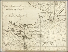
Striking early mapping of the Strait of Magellan, pre-dating the discovery of the Straits of Le Maire in 1616.
The map is the first depiction of the Strait of Magellan in a commercially published atlas. It stands out as one of the few sea chart style maps to appear in the Mercator-Hondius Atlas, showcasing the influence of Lucas Waghenaer's recently published sea charts, complete with a picturesque profile view and navigational soundings.
Oriented with the south on top, the map features a grand compass rose and three lavishly decorated strapwork cartouches. One of these displays a profile view of the entrance to the Strait, emulating the style of Waghenaer and the Dutch Rutter books from the late 16th century. The elaborate compass rose points towards the bottom, symbolizing north.
The map includes illustrations of six sailing vessels in the Pacific Ocean, various terrestrial and marine creatures, with the Southern Land being identified as Tierra Del Fuego. Within the Strait, it denotes about 20 geographical locations and 30 to 40 soundings. Navigation lines, or rhumb lines, radiate from the compass rose.
The map intriguingly transitions from the known coastline of Tierra del Fuego into speculative territories, slowly dissolving into an unexplored southern continent. This map holds a position of immense interest and charm among all regional American maps, marking a significant era in the exploration and discovery of the Americas and the maritime pathways between the Atlantic and Pacific. This historical artifact predates the discovery of Cape Horn in 1616.
Historically, the Strait of Magellan, named after the Portuguese explorer Ferdinand Magellan, was a significant discovery for its time. Its discovery in 1520 during the Spanish expedition marked the first known navigable route from the Atlantic Ocean to the Pacific. For more than a century, it served as the most important natural passage between the two oceans, until the discovery of Cape Horn provided a more accessible route in 1616.
Jodocus Hondius the Elder (1563-1612), or Joost de Hondt, was one of the most prominent geographers and engravers of his time. His work did much to establish Amsterdam as the center of cartographic publishing in the seventeenth century. Born in Wakken but raised in Ghent, the young Jodocus worked as an engraver, instrument maker, and globe maker.
Hondius moved to London in 1584, fleeing religious persecution in Flanders. There, he worked for Richard Hakluyt and Edward Wright, among others. Hondius also engraved the globe gores for Emery Molyneux’s pair of globes in 1592; Wright plotted the coastlines. His engraving and nautical painting skills introduced him to an elite group of geographic knowledge seekers and producers, including the navigators Drake, Thomas Cavendish, and Walter Raleigh, as well as engravers like Theodor De Bry and Augustine Ryther. This network gave Hondius access to manuscript charts and descriptions which he then translated into engraved maps.
In 1593 Hondius returned to Amsterdam, where he lived for the rest of his life. Hondius worked in partnership with Cornelis Claesz, a publisher, and maintained his ties to contacts in Europe and England. For example, from 1605 to 1610, Hondius engraved the plates for John Speed’s Theatre of the Empire of Great Britaine.
One of Hondius’ most successful commercial ventures was the reprinting of Mercator’s atlas. When he acquired the Mercator plates, he added 36 maps, many engraved by him, and released the atlas under Mercator’s name, helping to solidify Mercator’s reputation posthumously. Hondius died in 1612, at only 48 years of age, after which time his son of the same name and another son, Henricus, took over the business, including the reissuing of the Mercator atlas. After 1633, Hondius the Elder’s son-in-law, Johannes Janssonius, was also listed as a co-publisher for the atlas.
![[ Alaska / Cabo San Lucas / San Blas / Chile ] Views of Headlands and Islands on the Coasts of North West and South America](https://storage.googleapis.com/raremaps/img/small/88077.jpg)
![[Alaska, Northwest Coast and North Pacific Ocean] Der Noerdliche Theil des Grossenwelt Meeres . . . 1804](https://storage.googleapis.com/raremaps/img/small/80463.jpg)