|
||

|

|
|

|
The Most Important Map of Iceland After Ortelius and Mercator - Reynir Grétarsson, Author of Mapping Iceland
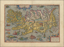
Finely colored map of Iceland published by Willem Janszoon Blaeu, a striking example of Blaeu's meticulous craftsmanship.
The map itself is a visual spectacle, teeming with captivating elements that bring the stark Icelandic landscape to life. An erupting volcano, a notable feature of the island's seismic activity, is prominently displayed, vividly capturing Iceland's fiery underbelly. Elsewhere, 2 fanciful sea monsters, likely drawn from sailors' tales, are shown in the southern waters, lending an element of adventure and mystery.
Sailing ships, indicative of the era's maritime pursuits, navigate the monster-infested seas, adding a layer of dynamism to the scene. The decorative cartouches, rendered with elaborate detail, add an aesthetic appeal while also providing information about the map's source and context. Two compass rose marks the cardinal directions, grounding the viewer's orientation.
The map credits Joris Carolos, an explorer who had personal experience with Iceland, as its primary source. However, many place names, or toponyms, seem to have been carried over from an earlier map by Abraham Ortelius.
The map includes a number of new islands and fjords, some of which are fictional, perhaps added to invoke a sense of discovery. The interior of the island, however, remains largely unchanged from previous representations.
The history of Iceland starts with its discovery and initial settlement by Norsemen, believed to be in the late 9th century. According to Icelandic sagas, specifically the "Landnámabók" or the "Book of Settlements", the first permanent settler was Ingólfr Arnarson, who made his home in what is now Reykjavík in 874 AD.
In the early years of settlement, land was claimed by those who arrived and could cultivate it. This period, known as the Age of Settlement, lasted until about 930 AD, at which point the island was almost entirely populated. The settlers established a unique form of governance - a parliamentary system known as the Althing, which is considered one of the world's oldest parliaments.
In 1000 AD, under the rule of the Norwegian King Olaf Tryggvason, Iceland converted to Christianity. The following centuries saw a decline in political independence. Iceland fell under Norwegian control in the mid-13th century, marking the end of the Icelandic Commonwealth. In 1380, Norway and Denmark were united under a single monarch, and Iceland, as a part of Norway's territories, came under Danish rule.
The 15th and 16th centuries were a difficult period for Iceland, marked by climatic hardship, disease, and pirate raids. Despite this, the country made a significant cultural contribution during this era. The 16th century saw the arrival of the Reformation, imposed by Denmark, leading to a transition from Catholicism to Lutheranism.
By the time Blaeu created his map in the 17th century, Iceland was still a Danish dependency. Its populace, while scattered across the rugged landscape, maintained a largely pastoral economy, reliant on fishing, agriculture, and sheep herding. Its culture was deeply rooted in the Norse traditions of its ancestors, and its sagas, passed down from generation to generation, echoed the deeds and tales of its early settlers.
Willem Janszoon Blaeu (1571-1638) was a prominent Dutch geographer and publisher. Born the son of a herring merchant, Blaeu chose not fish but mathematics and astronomy for his focus. He studied with the famous Danish astronomer Tycho Brahe, with whom he honed his instrument and globe making skills. Blaeu set up shop in Amsterdam, where he sold instruments and globes, published maps, and edited the works of intellectuals like Descartes and Hugo Grotius. In 1635, he released his atlas, Theatrum Orbis Terrarum, sive, Atlas novus.
Willem died in 1638. He had two sons, Cornelis (1610-1648) and Joan (1596-1673). Joan trained as a lawyer, but joined his father’s business rather than practice. After his father’s death, the brothers took over their father’s shop and Joan took on his work as hydrographer to the Dutch East India Company. Later in life, Joan would modify and greatly expand his father’s Atlas novus, eventually releasing his masterpiece, the Atlas maior, between 1662 and 1672.


![[ Iceland ] Isola d'Islanda](https://storage.googleapis.com/raremaps/img/small/98962.jpg)
![[ Iceland ] Tabula Islandiae Auctore Georgio Carolo Flandro](https://storage.googleapis.com/raremaps/img/small/91305.jpg)