|
||

|

|
|

|
Stock# 94406
Description
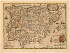
Beautiful manuscript sailing chart of the Spanish coastline around Estepona, in the Costa de Sol, halfway between Malaga and Gibraltar.
The map covers approximately twelve miles of coastline between Buenas Noches and Cancelada, with a few toponyms across the map including "Stampone," "tour a feu," (likely a lighthouse) and "aigude." In the ocean, a ship is shown with its anchor, and numerous soundings are shown throughout the map, indicative of the naval use of the map.
The map is beautifully executed in the classic French style, characterized by the teal-blue wash color and the red and yellow compass rose. The manuscript text on the verso describes the region of Cap de Moulin, near Malaga.
Condition Description
Pen and ink with wash color. Manuscript notes on verso. Corner in title reinstated in manuscript facsimile.
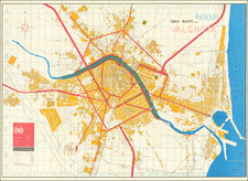
![[Grenada] Plano de Granada Comprobado con el Instituto Geogco. y Revisado por arquiteto municipal (Spain)](https://storage.googleapis.com/raremaps/img/small/61742.jpg)