|
||

|

|
|

|
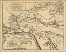
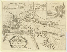
Plan of the Military & Naval Operations, under the command of Immortal Wolfe, & Vice Admiral Saunders, before Quebec, engraved and published by James Wyld in London on May 1st, 1841, offers an in-depth look at the strategic operations under the leadership of Major General James Wolfe and Vice Admiral Saunders, leading up to the pivotal events on the Plains of Abraham in 1759. This map was made in dedication to the United Services of the British Empire, commemorating their daring achievements during the Seven Years' War before Quebec.
During the mid-18th century, Britain and France found themselves locked in a struggle for global supremacy, a contest that spilled over into North America, culminating in the pivotal Battle of the Plains of Abraham in 1759. This skirmish marked the British conquest of Quebec and was a defining moment in the Seven Years' War. The map vividly brings to life the planning and preparations, illustrating the extensive naval and military details, from line of battleships to specific encampments.
The British naval force, under the direction of Vice Admiral Saunders, is detailed extensively, listing ships like the Neptune, Princess Amelia, and Royal William among others. Further, the map offers an insight into the ground operations, noting the roles of each regiment and brigade under Major General James Wolfe's leadership, highlighting the contributions of key officers and the number of troops in each formation.
Additionally, various tactical elements and positions are elaborated on, such as redoubts designed to command roads, defend key positions, and oppose sallies from the town. These details elucidate the tactical genius of British planning and the strategic depth that went into securing victory.
Equally notable is the prominent depiction of the "Death of General Wolfe" based on the celebrated painting by Benjamin West, a poignant testament to the sacrifices and valor exhibited during the confrontation.
This map is a testament to the profound military strategy and tactical execution during a key phase of the Seven Years' War. It not only depicts the geography and topography of the battlefield but also provides intricate insights into the deployments and movements that ultimately led to a pivotal moment in global history.
Rare.
James Wyld Sr. (1790-1836) was a British cartographer and one of Europe’s leading mapmakers. He made many contributions to cartography, including the introduction of lithography into map printing in 1812.
William Faden, another celebrated cartographer, passed down his mapmaking business to Wyld in 1823. The quality and quantity of Faden’s maps, combined with Wyld’s considerable skill, brought Wyld great prestige.
Wyld was named geographer to Kings George IV and William IV, as well as HRH the Duke of York. In 1825, he was elected an Associate of the Institution of Civil Engineers. He was one of the founding members of the Royal Geographical Society in 1830. Also in 1830, his son, James Wyld Jr., took over his publishing house. Wyld Sr. died of overwork on October 14, 1836.
James Wyld Jr. (1812-87) was a renowned cartographer in his own right and he successfully carried on his father’s business. He gained the title of Geographer to the Queen and H.R.H. Prince Albert. Punch (1850) described him in humorous cartographic terms, “If Mr. Wyld’s brain should be ever discovered (we will be bound he has a Map of it inside his hat), we should like to have a peep at it, for we have a suspicion that the two hemispheres must be printed, varnished, and glazed, exactly like a pair of globes.”
![Partie du Cours du Fleuve de Saint Laurent depuis Quebec jusqu'au Cap aux Oyes [on sheet with] Carte du Cours du Fleuve Saint Laurent depuis Quebec jusqu'a la Mer en Deux Feuilles ... 1761](https://storage.googleapis.com/raremaps/img/small/55185.jpg)