|
||

|

|
|

|
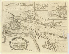
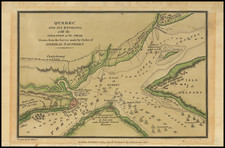
Scarce example of the Royal Magazine edition of Thomas Jefferys' map of the siege of Quebec of 1759, widely considered to be the most important printed military map in Canadian history.
This fascinating map embraces the environs of Quebec City and was one of the first maps to be printed in London following news of the British victory on the Plains of Abraham in 1759, the fateful showdown between the armies of General James Wolfe and the Marquis de Montcalm. It shows the city and topography in carefully rendered detail. All of the main scenes of action surrounding the British siege are shown, including the abortive attack on Beauport, the British Headquarters at Levis and the site of the decisive Battle of the Plains of Abraham. Interestingly, each vessel of the British fleet, under the overall command of Admiral Saunders, appears in pictographic form, with the names of each ship labeled.