|
||

|

|
|

|
With Early Pencil Corrections.
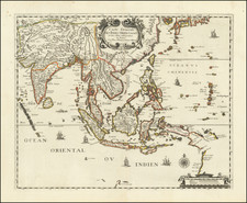
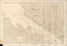
"A Chart of the Straits of Malacca and Sincapore" is a richly detailed sea chart prepared by Thomas Jefferys, Geographer to the King, and published by Laurie & Whittle in 1794. This comprehensive chart provided 18th-century navigators with essential details about the Straits of Malacca and Sincapore (Singapore), prominent trade routes linking the Pacific and Indian oceans.
The map features a helpful guide to the Malay terminology, clarifying that "Pulo or Pooloo" stands for an island, "Tanjong" signifies a point, and "Songi" refers to a river. This guide would have been crucial for foreign navigators to understand local toponyms and communicate effectively with the regional communities.
A note in the lower left corner provides navigational "Observations by M. Sampson Hall in 1784" offering additional guidance about the terrain, nearby islands, and depths of certain sea routes. It includes an account of Hall's passage between two round islands near the southern end of Pooloo Baniack.
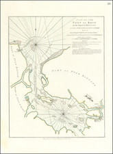
The map also features two inset charts: "Siddo Harbour Miles S.by E. from Kings Point near Afheen" and "A Plan of the Road of Achen with the Several Passages between the Adjacent Islands".
The chart provides extensive coastal profiles in the upper right corner, aiding mariners in identifying landforms from the sea. Notably, the map shows an impressive amount of detail around "Sincapore" and the "Straits of Sincapore," regions that would later grow into major global shipping hubs. Overall, this chart is a testament to the meticulous nature of 18th-century cartography and its role in facilitating global maritime trade.
Thomas Jefferys (ca. 1719-1771) was a prolific map publisher, engraver, and cartographer based in London. His father was a cutler, but Jefferys was apprenticed to Emanuel Bowen, a prominent mapmaker and engraver. He was made free of the Merchant Taylors’ Company in 1744, although two earlier maps bearing his name have been identified.
Jefferys had several collaborators and partners throughout his career. His first atlas, The Small English Atlas, was published with Thomas Kitchin in 1748-9. Later, he worked with Robert Sayer on A General Topography of North America (1768); Sayer also published posthumous collections with Jefferys' contributions including The American Atlas, The North-American Pilot, and The West-India Atlas.
Jefferys was the Geographer to Frederick Prince of Wales and, from 1760, to King George III. Thanks especially to opportunities offered by the Seven Years' War, he is best known today for his maps of North America, and for his central place in the map trade—he not only sold maps commercially, but also imported the latest materials and had ties to several government bodies for whom he produced materials.
Upon his death in 1771, his workshop passed to his partner, William Faden, and his son, Thomas Jr. However, Jefferys had gone bankrupt in 1766 and some of his plates were bought by Robert Sayer (see above). Sayer, who had partnered in the past with Philip Overton (d. 1751), specialized in (re)publishing maps. In 1770, he partnered with John Bennett and many Jefferys maps were republished by the duo.
Robert Laurie (ca. 1755-1836) and James Whittle (1757-1818) formed their Fleet Street, London-based firm upon the 1794 death of their employer Robert Sayer, himself one of the dominant print and mapmakers of the last half of the 18th century.
Laurie & Whittle started managing Sayer's business as early as 1787. They took over all managerial duties when Sayer's health flagged in 1792, and they changed the imprint in 1794 upon his death. Sayer left the two a 21-year lease on the shop (at £100 a year) and on Sayer's Bolt Court premises, as well as an option to acquire stock and equipment at a preferential price of £5,000 payable over three years.
Robert Laurie retired from the firm in 1812, and his role was assumed by his son, Richard Holmes Laurie (1777-1858). The younger Laurie worked with James Whittle until the latter died in 1818. After R. H. Laurie died in 1858, Alexander George Findlay, FRGS (1812-1875) purchased the firm from his daughters. The firm continues today under another name, specializing in yachting charts.
Laurie & Whittle were prolific print and map publishers, and throughout their careers, they produced numerous very important and rare works. They carried on Robert Sayer's atlas business and were responsible for editions of The Complete East-India Pilot and The American Atlas.
![[Untitled Map of Southeast Asia & The Philippines]](https://storage.googleapis.com/raremaps/img/small/47007.jpg)