


|
||

|

|
|

|
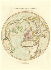
[America Map in set of 4] The Most Elaborate of the Dutch Golden Age Wall Maps of Europe. Heightened in Gold and Lapis Lazuli.
Dedicated in English to Charles II. Probably Prepared on the Advent of the Triple Alliance (1668-1672) and the Expansion of Rights of the EIC (1670).
Previously unknown first state of Nicolas Visscher's monumental wall map of America, celebrating the creation of the Triple Alliance, in remarkably preserved original condition.
Unlike most wall maps of the period, the set of four maps were almost certainly created specifically to celebrate an important historical event. In fact, this is the only example of which we are aware where the title of a wall map specifically notes that it is being prepared in conjunction with three other wall maps to form a set of four. Equally fascinating is the Visscher's choice of and English language title for the map of Europe, with a remarkable dedication to Charles II. This is the only Dutch wall map of which we are aware which includes an English title.
The creation of the Triple Alliance (1668 - 1672) was an event of monumental importance for the Netherlands, Sweden and England. The alliance was short-lived since both Sweden and England backed France at the outset of the Franco-Dutch War four years later, but it marked the point at which England and the Dutch came to see France as a common threat. The Triple Alliance was the forerunner of the Grand Alliance, which fought the 1688-1697 Nine Years' War and the 1701-1714 War of the Spanish Succession.
Issued in collaboration with Hugo Allard, partriach of the Allard map publishing family, Visscher's set of continental maps are among the most lavish continental wall maps produced during the Golden Age of Dutch Cartography, and were likely commissioned to commemorate the creation of the Triple Alliance, possibly as gifts from the Dutch to English and Swedish royalty. Remarkably, there were previously no other known sets of the first state until the discovery of this set in the Ericsberg Palace, which which came to market in June 2022. The only other surviving complete set of Visscher's four continental wall maps is a later state in the Swedish National Library, with a revised dedication to William III (William of Orange) and revisions in the map of Asia, published shortly after William III's assent to the throne of England in 1689.
The unique survival of the set of maps is made all the more fascinating by its remarkable original condition. The survival rate of these wall maps is extraordinarily low and those that do survive are typically in poor condition, heavily oxidized, browned, soiled or extensively restored.
Dating The Map / And Map Set
Relatively little is known about this remarkable set. This is in large part because other than the Swedish National Library set, there are no other surviving individual examples of the wall maps to include the city views, text and decorative title banners. All other known examples are limited to the 6 map sheets, except a single example of the map of America which Burden describes as having decorative panels of all four sides of the map.
While Burden and Betz believed that the maps of Africa and America were issued in about 1682 or after, this conclusion was reached without the benefit of knowing the contents of the current set, which includes both the dedication and portrait to Charles II of England on the map of Europe and the coat of arms of Charles II in the upper left corner of the map of Asia. The Bibliotheque National de France also holds a copy of this map of Europe with the portrait of Charles II, which they dated to 1660-1685. By contrast, in the Swedish National Library set, both are includes a portairt of William II on the map of Europe and a completely revised coat of arms in Asia, as well as several changes to the content of the inset of Australia.
The inclusion of the coat of arms of Charles II on the map of Asia likely coincides with his decision to grant autonomous governance to the East India Company (EIC) over the lands it controlled. In an act aimed at strengthening the power of the EIC, King Charles II granted the EIC (in a series of five acts around 1670) the rights to autonomous territorial acquisitions, to mint money, to command fortresses and troops and form alliances, to make war and peace, and to exercise both civil and criminal jurisdiction over the acquired areas.
Wall Maps For Royalty
Visscher's maps are drawn from virtually unobtainable wall maps of the continents created by the Blaeu family between 1655 and 1659, which at the time were considered among the most cartographically advanced work of the period and available only to the wealthiest patrons.
The present map is a spectacular example of the grand genre of wall or parlor maps that enjoyed an iconic place in 17th and early 18th-century Europe. During the Golden Age of Dutch Cartography, these large, highly decorative and expensive productions were considered to be the ultimate signs of wealth and intellectual sophistication. By the second half of the 17th Century, these lavish Dutch works were also being copied by leading mapmakers in France and Italy, as the demand spread through the continent.
Visscher's maps of Europe and Africa are drawn from Blaeu's wall maps of the 1650s. The maps of America and Asia would seem to be far more original in their content. Each is printed on 6 sheets, with an elaborate title at the top, 2 series of city views on the sides, and text below.
Contextually, there is strong evidence to suggest that this set of maps was custom made for a Swedish royal family, after Sweden joining the Triple Alliance. Unlike most of the surviving wall maps from this period, the present set is heightened in gold and includes an elaborate blue and gold leaf title banner, employing a lapis lazuli blue which at the time was even more expensive than gold. No other surviving example of the set exists and no other single map includes the same lavish decoration.
The only similar set, held by the Swedish National Library, includes revisions to reflect a changing British Monarch (William III) and includes the same lavish title banners with gold and lapis lazuli, but with a completely new set of text panels and revised order of city views and decorative embellishments. The text below the maps are in Dutch. Moreover, there are changes to the plate, with the addition of two rivers in western Australia and other revisions. The Hugo Allard text is now in Latin and French (not Dutch), with Allard's shop address in French, strongly indicating very different times of publication. All signs point to a re-issuance of the circa 1670 original issue following the coronation of William III in 1685.
Remarkably, the only two surviving sets of the Visscher's maps were preserved in Swedish royal collections, with remarkably similar color, gold and lapis lazuli finishes. And yet, the maps show significant differences that can only be explained by a significant passage of time.
Rarity
The set of four wall maps is the only known surviving example of the first state. The Swedish National Library holds a similar set, with significant revisions on the maps of Asia and Europe, reflecting a publication date after the coronation of William III of England in 1689.
Individual examples of the map of America are known to survive in the Bibliotheque National de France (lacking decorative panels) and a private American collection (for decorative panels).
Provenance: Ericsberg Palace, Södermanland County, Sweden. Acquired by BLR Antique Maps in June 2022.
Hugo (or Huych) Allard (or Allardt) (1627–1684 or '91) was a draughtsman, engraver, and painter during the Dutch Golden Age of cartography. Based in Tournai and Amsterdam, he was the founder of a prominent family of Dutch mapmakers, publishers, and print sellers. Allard set up his cartography business around 1645, and his first works were mostly reissues of earlier maps. Although not as prominent as the Blaeu family or Henricus Hondius and Jan Janssonius, Hugo Allard’s work, from about 1640 to 1680, is considered to be just as fine in quality. His output was relatively small, and his maps were mostly published as loose, separate issues, but they were well-designed and finely engraved. After Allard’s death, he left his business to his son, Carel. There is some confusion about when he died; some sources state 1684, others say 1691.
Nicolaas Visscher II (1649-1702) was a prominent Dutch cartographer and publisher during the late 17th century. He was the grandson of Claes Janszoon Visscher and the son of Nicolaes Visscher I, both of whom were also renowned cartographers in their own right. After his father's death in 1679, Nicolaas Visscher II took over the family's map publishing business.
In 1680, he married Elizabeth Verseyl from Gouda, and in 1682, he obtained a new privilege from the States of Holland and West Friesland to protect his maps and publications from being copied. Visscher II continued the family tradition of producing high-quality maps, atlases, and globes, often with elaborate and decorative elements. He maintained the Visscher family's reputation for accuracy and craftsmanship in the competitive world of Dutch cartography until his death in 1702. After his death, his widow, Elizabeth, and later his son, also named Nicolaas, continued the business until around 1726.
![[ Populating Atlantis ] Atlantis Insula . . .1694](https://storage.googleapis.com/raremaps/img/small/85045.jpg)
![[Spectacular Set of Wall Maps of the Continents Dedicated to King Charles II of England, &c.]](https://storage.googleapis.com/raremaps/img/small/93614.jpg)

![La Florida [with] Guastecan [with] Peruviae Avriferae Regionis Typus](https://storage.googleapis.com/raremaps/img/small/89451.jpg)
![[ World & Continents ] Typus Orbis Terrarum / Americae Sive Novi Orbis Nova Descriptio / Asiae Nova Descriptio / Africae Tabula Nova / Europae](https://storage.googleapis.com/raremaps/img/small/99250.jpg)