|
||

|

|
|

|
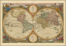
Fine examples of Visscher's famous set of five maps, consisting of separate maps of the Americas, Africa, Asia, Europe, and the World. These highly influential and decorative maps showcase the distinctive cartographic style of the Dutch Golden Age.
Visscher's maps became the prototype for Dutch maps for the next 50 years. They feature rich illustrations in the interior of each continent, along with numerous ships at sea and elaborate cartouches. Much of the cartographic details derive from Joan Blaeu's wall maps, including that of the world, published in 1648. The set includes a dedication cartouche to Nicolas Witsen, the Mayor of Amsterdam and a driving force behind many voyages of commerce and discovery at the time.
In particular, the map of the Western Hemisphere shows California as an Island and a small slice of New Zealand at the lower left corner, next to the title cartouche. It includes one massive open-ended Great Lake, a conjectural Northwest Passage, the Straits of Anian, and California appearing in the Briggs model.
The world map is a beautiful full-color double-hemisphere map, first published in 1658. Artist Nicolaes Berchem has introduced dramatic classical scenes representing the rape of Persephone, Zeus being carried across the heavens in an eagle-drawn chariot, Poseidon commanding his entourage, and Demeter receiving the fruits of the Earth. The world map also includes a set of smaller polar hemispheric projections at the top and bottom of the map.
Visscher's world map would become the prototype for not only a generation of large-format Dutch world maps, but also a series of reduced-sized biblical world maps by Stoopendahl and others. This set of five maps offers a remarkable insight into the cartographic expertise and artistic talent of the Dutch Golden Age.
The popular misconception of California as an island can be found on European maps from the sixteenth through the eighteenth centuries. From its first portrayal on a printed map by Diego Gutiérrez, in 1562, California was shown as part of North America by mapmakers, including Gerardus Mercator and Abraham Ortelius. In the 1620s, however, it began to appear as an island in several sources. While most of these show the equivalent of the modern state of California separated from the continent, others, like a manuscript chart by Joao Teixeira Albernaz I (ca. 1632) now in the collection of the National Library of Brasil shows the entire western half of North Americas as an island.
The myth of California as an island was most likely the result of the travel account of Sebastian Vizcaino, who had been sent north up the shore of California in 1602. A Carmelite friar, Fray Antonio de la Ascensión, accompanied him. Ascension described the land as an island and around 1620 sketched maps to that effect. Normally, this information would have been reviewed and locked in the Spanish repository, the Casa de la Contratación. However, the manuscript maps were intercepted in the Atlantic by the Dutch, who took them to Amsterdam where they began to circulate. Ascensión also published descriptions of the insular geography in Juan Torquemada’s Monarquia Indiana (1613) (with the island details curtailed somewhat) and in his own Relación breve of ca. 1620.
The first known maps to show California as an island were on the title pages of Antonio de Herrera’s Descripción de las Indias Occidentales (1622) and Jacob le Maire's Spieghel Der Australische Navigatie (1622). Two early examples of larger maps are those by Abraham Goos (1624) and another by Henry Briggs, which was included in Samuel Purchas’ Hakluytus Posthumus or Purchas his Pilgrimes (1625). In addition to Briggs and Goos, prominent practitioners like Jan Jansson and Nicolas Sanson adopted the new island and the practice became commonplace. John Speed’s map (1626-7), based on Briggs’ work, is well known for being one of the first to depict an insular California.
The island of California became a fixture on mid- and late-seventeenth century maps. The island suggested possible links to the Northwest Passage, with rivers in the North American interior supposedly connecting to the sea between California and the mainland. Furthermore, Francis Drake had landed in northern California on his circumnavigation (1577-80) and an insular California suggested that Spanish power in the area could be questioned.
Not everyone was convinced, however. Father Eusebio Kino, after extensive travels in what is now California, Arizona, and northern Mexico concluded that the island was actually a peninsula and published a map refuting the claim (Paris, 1705). Another skeptic was Guillaume De L’Isle. In 1700, De L’Isle discussed “whether California is an Island or a part of the continent” with J. D. Cassini; the letter was published in 1715. After reviewing all the literature available to him in Paris, De L’Isle concluded that the evidence supporting an insular California was not trustworthy. He also cited more recent explorations by the Jesuits (including Kino) that disproved the island theory. Later, in his map of 1722 (Carte d’Amerique dressee pour l’usage du Roy), De L’Isle would abandon the island theory entirely.
Despite Kino’s and De L’Isle’s work, California as an island remained common on maps until the mid-eighteenth century. De L’Isle’s son-in-law, Philippe Buache, for example, remained an adherent of the island depiction for some time. Another believer was Herman Moll, who reported that California was unequivocally an island, for he had had sailors in his offices that claimed to have circumnavigated it. In the face of such skepticism, the King of Spain, Ferdinand VII, had to issue a decree in 1747 proclaiming California to be a peninsula connected to North America; the geographic chimera, no matter how appealing, was not to be suffered any longer, although a few final maps were printed with the lingering island.
![[Pictorial World Map Gameboard]](https://storage.googleapis.com/raremaps/img/small/88775.jpg)