|
||

|

|
|

|
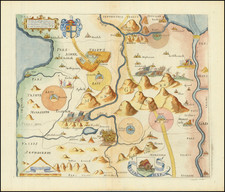
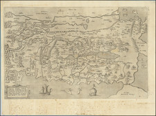
This striking woodblock print, entitled Cesta Synůw Izraelských z Egipta , is a significant artifact from the first Czech edition of M.H. Bunting's Itinerarium Sacrae Scripturae, to gest Putowánj Swatých. Published in Prague by D. Adam z Veleslavina in 1592, the map provides a pictorial representation of the journey of the Israelites from Egypt to the Holy Land.
The Exodus, a fundamental narrative in Jewish, Christian, and Islamic traditions, recounts the liberation of the Israelites from slavery in Egypt and their journey to the promised land under the leadership of Moses. This woodblock print brings to life this ancient narrative, with a detailed rendering of northern Egypt, including the Nile Delta, and Israel, featuring Jerusalem and the Dead Sea.
As a map from the Czech edition of Bunting's work, the map also bears witness to the expansion of Biblical knowledge across Europe in the late 16th century. It reflects the broader historical context of the Protestant Reformation and the proliferation of printed texts, which contributed to the democratization of religious knowledge. In its portrayal of a seminal religious narrative, this woodblock print unites geographical and spiritual exploration, providing a glimpse into both the Biblical past and the historical moment of its creation.
Henrich Bunting was a Protestant theologian and teacher born in Hanover, in what is now Germany. He attended the University of Wittenberg and graduated in 1569. He then began work as a preacher but caused some controversy with his teachings; he was dismissed from appointments in both Lemgo and Goslar.
He is best known today for his book, Itinerarium Sacrae Scripturae (Travel book through Holy Scripture), a travel collection and commentary of the geography of the Bible. The book provided the most complete summary of biblical geography then available and described the Holy Land by following the travels of various notable people from the Old and New Testaments. First published in Madgeburg in 1581, Itinerarium Sacrae Scripturae was a very popular book for the time. Over 60 editions were published between 1581 and 1757.
A particularly notable feature of the book were its many woodcut maps, many of them showing unique depictions of geographic features and continents. In addition to the conventional maps, the book also contained three figurative maps; the world depicted using a cloverleaf design (thought to possibly represent the Trinity with Jerusalem in the center), Europe in the form of a crowned and robed woman, and Asia as the winged horse Pegasus.