|
||

|

|
|

|
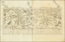
Fine and fascinating example of Montanus's map of the Holy Land, which originally appeared in his Polyglot Bible, one of the most important 16th-century editions of the Testaments.
The map shows Canaan at the time of Abraham and extends to the neighboring regions. The map is orientated with north at the left of the map. All the major holy cities and sites can be identified. Text on the map is both in Latin and in Hebrew.
This example of the work is extensively annotated in an early Latin hand. Numerous place names are added, both for well-known features (such as the Jordan River) and for less well-known places (Sedes Jacob). The annotations above and below the map appear to describe the geography of the region.
Montanus's Polyglot Bible was the source of much consternation at the time that it was published. It was compiled using early sources by some of the foremost Humanists of northern Europe and published by Plantin's leading press. However, the use of Aramaic sources caused issues in Montanus's native Spain, where he was accused of being overly forgiving to Jewish writers, an issue that required Montanus to visit Pope Gregory XIII.
![[Cyprus, Holy Land, Syria Middle East] Tabula Asiae IIII](https://storage.googleapis.com/raremaps/img/small/100937.jpg)
![[Solomon's Kingdom] Regnum Salomonicum Seu Tabula digesta ad Libros Iudicum Regum, Paral. et Prophet Per Eparchias XII, Mox Regna duo Auctore Phil. de la Rue . . .](https://storage.googleapis.com/raremaps/img/small/92371.jpg)
![Descriptio Accurata Terrae Promissae Per Sortes XII [and] Terre Sainte Moderne . . .](https://storage.googleapis.com/raremaps/img/small/94713.jpg)