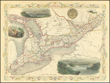
|
||

|

|
|

|
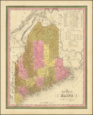
A meticulously detailed map of Maine and the contiguous parts of New Brunswick and Nova Scotia, this cartographic work highlights the boundary claims of the United States and Great Britain along the Maine-Canada border during the contentious period that culminated in the resolution of the Republic of Madawaska dispute.
Spanning from Portland and the mouths of the Kennebec and Androscoggin Rivers in the south to the St. Lawrence River in the north and the Connecticut River in the west, the map illustrates the disputed territories and the subsequent establishment of the unrecognized Republic of Madawaska. This region, situated in the northwest corner of Madawaska County in New Brunswick, also extended into Aroostook County in the US state of Maine and parts of Quebec.
The Republic of Madawaska's origins can be traced back to the Treaty of Paris (1783), which defined the border between the United States and the British North American colonies. However, the Madawaska region remained a contentious issue until the signing of the Webster-Ashburton Treaty in 1842. The map not only documents the disputed lands but also highlights key events in the region's history, such as the arrival of US settler John Baker, his petition to Maine for inclusion in the state, the raising of the US flag in the region, and the subsequent British response, which escalated the situation and led to diplomatic arbitration.
Published in either 1838 or 1839, this lithographic version of the map, which is one of several editions, provides valuable insights into the complex geopolitical landscape of the Maine-Canada border region during the early 19th century. Its detailed representation of the area and the inclusion of notable land grants make it a fascinating historical document that sheds light on a pivotal moment in North American border history.