|
||

|

|
|

|
Stock# 86715
Description
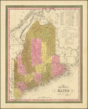
Marvelous example of Tanner's map, from the last edition of Tanner's Universal Atlas.
The map is hand colored by counties, and shows towns, roads with distances, railroads, and a host of other details. The key shows counties and towns in each state, with populations, and populations on a decade by decade basis since 1765. Primitive early northern counties are still incomplete.
![[ Maine ] Carte Geographique, Statistique et Historique Du Maine](https://storage.googleapis.com/raremaps/img/small/79342.jpg)