|
||

|

|
|

|
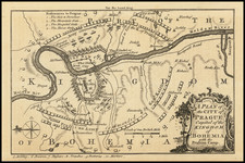
This 1646 map of Bohemia, engraved by Petrus Kaerius (Pieter van den Keere) after John Speed's original design, offers a detailed depiction of the region during the 17th century. Centered on "Praga" (Prague), the map extends to Moravia and Silesia to the east, and Voteland and Bavaria to the west, capturing the intricate geography and political divisions of the area.
Although John Speed (1552-1629) is credited with the original design, it was Petrus Kaerius, a prominent Dutch engraver, who adapted Speed's work into this miniature format. Kaerius's meticulous engraving and clear presentation of information make this map an excellent example of 17th-century cartography.
Despite its small size, the map provides a wealth of information about the region's towns, cities, and geographical features. The political boundaries and major roads are clearly marked, giving viewers a comprehensive understanding of Bohemia and its surrounding areas during this period.
In summary, this 1646 map of Bohemia, based on John Speed's original design and engraved by Petrus Kaerius, offers a fascinating glimpse into the region's geography and politics during the 17th century. Its precise engraving and rich detail make it a valuable resource for collectors, historians, and enthusiasts interested in the cartographic history of Bohemia and Central Europe.
John Speed (1551 or '52 - 28 July 1629) was the best known English mapmaker of the Stuart period. Speed came to mapmaking late in life, producing his first maps in the 1590s and entering the trade in earnest when he was almost 60 years old.
John Speed's fame, which continues to this day, lies with two atlases, The Theatre of the Empire of Great Britaine (first published 1612), and the Prospect of the Most Famous Parts of the World (1627). While The Theatre ... started as solely a county atlas, it grew into an impressive world atlas with the inclusion of the Prospect in 1627. The plates for the atlas passed through many hands in the 17th century, and the book finally reached its apotheosis in 1676 when it was published by Thomas Bassett and Richard Chiswell, with a number of important maps added for the first time.
![Turingiae Noviss Descript. Per Iohannem Mellinger Halens [with] Misniae et Lustaiae Tabula Descripta a. M Bartholomeao Sculteto Gorlit.](https://storage.googleapis.com/raremaps/img/small/61448.jpg)
![[ Glatz - 7 Years War ] Des neuen Kriegs Theaters 22. Supplement Plan der Belagerung der Stace und Vestung Glaz...](https://storage.googleapis.com/raremaps/img/small/99034.jpg)
![[ Holy Roman Empire ] Germania, Non ea tantum quae Rheno, Vistula, Danubio, mariqz Germanico Veteribus claudebatur; Sed tota illa continens quae hodie communiter Germanica lingua utitur . . .](https://storage.googleapis.com/raremaps/img/small/99236.jpg)