|
||

|

|
|

|
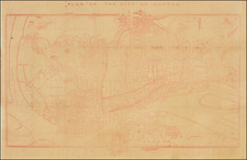
An intricate representation of early 20th-century Shanghai, The New Map and Street Directory of Shanghai City, is a testament to the rich, multifaceted urban history of one of the world's most populous cities. Conceived around 1916, this map stands as a testament to the urban dynamics and evolving spatial relations in the wake of the Qing dynasty and the advent of the Republic of China.
The New Map and Street Directory of Shanghai City is further distinguished by an accompanying 8-page street index in both Russian and English, a nuanced reflection of the city's international character and its emerging status as a cosmopolitan hub in the early 20th century.
Shanghai in the early 1900s was a city in flux, undergoing radical transformation due to its status as a treaty port and its unique place in global geopolitics. The inclusion of a Russian-language street index alongside English, just prior to the influx of White Russians fleeing the Civil War, anticipates the city's imminent demographic transformation. Shanghai would soon become a prominent refuge for those fleeing the tumultuous events in Russia, significantly enriching its cultural and social landscape.
Born of a time when Shanghai's territorial expansion was well underway, the map delineates the jurisdictional boundaries of twelve counties, including Shanghai County, Songjiang County, Nanhui County, and others. While this coverage was broader than modern Shanghai, the map's focus remained on the traditional Chinese boundary and the concessions. In essence, it underscores the city's dual identity, highlighting its place as both a traditional Chinese city and an international hub of commerce, culture, and diplomacy.
However, the map's fidelity to the contemporary geographic realities is not without imperfections. Despite the French Concession's expansion to Xujiahui by that period, the map confines its representation of the area to an inset in the lower left corner. Similarly, while the map does acknowledge the existence of Japanese and American concessions and the western boundary of the British concession, it somewhat underestimates their spatial reach and development extent.
Nevertheless, this map serves as a window into the urban fabric of Shanghai at that time. It faithfully records the Japanese presence in the northern part of the city, the expansion of the American concession, and the growth of the British concession to the west of Jing'an Temple. Its depiction of the early Republic of China era’s newly established roads and facilities, including Wei Hai Wei Road and Edward VII Road, among others, is both informative and revealing.
The New Map and Street Directory of Shanghai City employs an unusual and flexible layout. It integrates an irregular cross-shaped design, a paper-saving technique that maintained the consistency of the scale reference. This layout adaptation, reflecting Shanghai's unique urban morphology, is seldom observed in Chinese urban maps, marking this map as an intriguing departure from the norms of cartographic presentation of the era. Through its blend of precision and idiosyncrasies, this map illuminates the shifting cultural and urban landscapes of Shanghai in the early 20th century.
There were apparently at least three known versions of different publication years, namely 1911, 1916, and 1918.
![[English Edition!] Chinae, olim Sinarum regionis nova descriptio. auctore Ludouico Georgio.](https://storage.googleapis.com/raremaps/img/small/71123.jpg)
![Plan du Typa ou de Macao [with] Plan De La Baye D'Awatwska…Du Kamtschatka [with] Parti Du Japon ou Nipon](https://storage.googleapis.com/raremaps/img/small/36150.jpg)
![(Southwestern China) Iunan, Queicheu, e Quangsi Provincie della China. . . [Yunnan, Guizhou, and Guangxi Provinces of China]](https://storage.googleapis.com/raremaps/img/small/70078mp2.jpg)