|
||

|

|
|

|
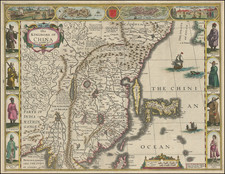
Rare Early Copy of Daniel Vrooman's Monumental Manuscript Map of Canton, China.
Interesting early plan of Canton, based upon Daniel Vrooman's manuscript map of Canton.
Vrooman's manuscript plan offered a little-seen view of Canton on the eve of the Second Opium War. Constructed by Vrooman using Chinese converts as spies to pace off and describe sections of Canton which were closed to foreigners, Vrooman's map is among the earliest surviving large western maps of Canton and contains intricate details of life and trade in the port city. First issued in about 1855, the map shows the city’s streets, the walls of the Old City, and the developed areas near the riverside. Other details on the map include ponds and the many rice paddies surrounding the city.
The present map incorporates many of the same features as Vrooman's map, including the stylized hills at the top and bottom of the map. Many of the city’s prominent buildings are also shown with careful detail. These include the compounds of officers and officials, temples, gates, and parade grounds. Several pagodas are also labeled. One of these, in the northwest of the Old City, is likely the Temple of the Six Banyan Trees. The Temple, first built in 537 AD, was rebuilt with an octagonal base in 1097 AD. Intricate drawings such as this pagoda allow readers to identify individual buildings and mark this map as an important document for historical research.
The primary difference between the two maps would seem to be the area on the present map labeled "Shamien Site" (shown as 4 forts and an area labeled "Boats Rafts and Houses on Piles" on the Vrooman map), and the area labeled "Old Factory Site" (previously the area occupied by the American, French and English factories, the only spaces in which Westerners were allowed, prior to the conclusion of the First Opium War).
Canton and China’s trade with the West
This map was finished just before a period of tremendous change for the city of Canton. The city has always been an important port city and administrative center. Ibn Battuta, the Moroccan intellectual, visited in the fourteenth century and wrote of the large shipyards at work there. Foreign visitors were banned, however, and trade restricted to formal delegations, in the late fourteenth century.
The Portuguese made their way to the city in the early sixteenth century. After a half-century of tension and conflict, they were eventually allowed to trade, although they warehoused their goods at Macau instead of Canton. From the late seventeenth century, the Qing Dynasty loosened its restrictions on foreign trade somewhat, allowing a few ships each year from several Western Empires. However, Westerners were still not allowed within the Old City walls and were restricted to factories near the waterline.
From 1757, the Chinese employed what became known as the Canton System, which made Canton the sole port of entry for Western goods into China. A cohort of Chinese merchants, the Cohong, mediated between the Chinese government and Western traders, and they operated out of the Thirteen Factories area noted on this map. The factories were destroyed by fire in 1822 and rebuilt.
Though the Western empires tolerated the Canton System, they did not like it and wanted more open access to Chinese goods, especially tea, and markets. By the late-eighteenth century, the British had accumulated a massive trade deficit as China had no interest in Western goods; they only accepted silver as payment. The East India Company began to bring opium from its Indian plantations to China instead of silver, causing a massive increase in the number of Chinese addicted to the substance.
Although the Chinese banned the import of opium, the trade continued. When China attempted to halt the trade in 1839, the British responded with force. During this conflict, the First Opium War, the British captured the Thirteen Factories in March 1841. In May, the Chinese mounted a counter-offensive, retaking the British Factory. Stray fireboats meant to light the Royal Navy fleet afire instead set flame to the waterfront, which has been rebuilt as seen in this map. The British successfully countered and took control of the city on May 30, 1841.
The war ended with the Treaty of Nanking (1842), which forced the Chinese to allow British, and eventually other, traders to live in several Chinese ports unmolested. It also granted them the liberty to trade with whomever they chose. Additionally, Britain was granted a colony at Hong Kong.
Unsurprisingly, the Chinese government was dissatisfied with the Treaty of Nanking. The British too were not entirely satisfied, as they still did not have the ideal open trade conditions they desired. In 1856, only a year after this map was finished, the powers went to war again.
The Second Opium War actually began in Canton, where Chinese marines seized a British-registered ship, the Arrow, in October 1856. The British bombarded Canton in late 1856, causing many fires, and they took the city in late 1857, with the support of the French. Eventually, Anglo-French forces advanced and burned the Summer Palaces near Beijing. The Convention of Beijing, in October 1860, saw China grant diplomatic presence in Beijing to the Russian, French, and British; the payment of an indemnity, and the cession of Kowloon to Britain. The opium trade was also declared legal and Christianity recognized.
In Canton, the Thirteen Factories were destroyed for a final time.
Daniel Vrooman and his mapping practice
Daniel Vrooman was an American missionary who was assigned to Canton in 1852, at a time when Westerners were still not allowed inside the walls of Canton's Old City. If Vrooman, as an American, was not allowed within the walls of the Old City, how did he produce such a detailed plan? Vrooman used local informants to give him details of architecture and the city’s layout. He also trained a local man to pace out the distance between principal sites, with the city gates as anchor points. Vrooman then compared these measurements to his own, which were based on the angles provided by landmarks in the suburbs of the Old City. Later, when the city was finally opened to Westerners, the map was found to be remarkably accurate.
Several later maps based upon Vrooman's work, issued after the Second Opium War, are known to survive, including the aforementioned British Library example; an 1857 lithographical version of the map, known in a single example in the collection of the American Antiquarian Society; and an 1860 Vrooman map, which is substantially similar to the 1857 map, which was likely printed in Canton.
Rarity
The separate map is rare on the market. We have not previously seen the map.
Daniel Vrooman (1818-1895) was an American missionary who served in China. He made the first Western map of Canton, finished in 1855.
Vrooman was sent to China with his wife, Elizabeth Clemens, by the American Board of Commissioners for Foreign Missions in 1852. They settled in Guangzhou, then called Canton. Vrooman was intrigued by Chinese technology and science, as evidenced by a letter he sent to Scientific American, published in 1853.
His curiosity was limited somewhat by the closure of the Old City to Westerners. Undaunted, Vrooman used local informants and a convert he trained in measurement to assist him while he drew his large-scale plan of Canton.
Elizabeth died in Macao only two years after they arrived in China. Daniel remarried Maria Wilberforce and the couple stayed on as missionaries. Vrooman also served as American vice-consul. He is credited with introducing mechanized cotton spinning to Guangzhou as well. His other published work, a Cantonese phonetic alphabet, was published in 1863.
Vrooman retired from the ABCFM’s mission in Guangzhou in 1866, around the time his second wife died. He continued to work as an independent missionary in the area, until 1878 when he became superintendent of a mission to the Chinese based in Victoria, Australia. After retiring in 1881, he returned to the United States, where he died in California in 1895.
![[ Beijing ] Peking](https://storage.googleapis.com/raremaps/img/small/101285.jpg)