|
||

|

|
|

|
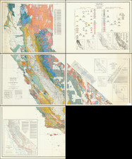
The Elusive 11th Map of the Hayden Surveys.
The Summative Geological Map of Hayden's Cartographic Career.
The extremely rare Map 11 of Hayden's Maps and Panoramas Twelfth Annual Report, included in only a vanishing fraction of his reports.
Hayden's General Geologic Map shows the vast swath of land surveyed, stretching from northern New Mexico and Arizona through Utah, Colorado, Kansas, Nebraska, Wyoming, Idaho, and into the Dakotas and Montana to the Canadian border. It shows the region mapped under his great surveys during the eleven-year period from 1869 to 1880, in which, every summer, geologists, scientists, cartographers, photographers, and artists would trek across the country to map these vast expanses of the American West.
This map represents one of the first great summative geological maps of the Rockies, published by the first survey to understand their true geological nature. Nine types of geological strata are shown throughout:
- Alluvial
- Tertiary
- Post Cretaceous
- Cretaceous
- Jura Trias
- Carboniferous
- Silurian
- Volcanic
- Metamorphic
In essence, this is the overview geological map for Hayden's career, covering his work on the western Plains and in the Rockies. Hayden's Maps and Panoramas were first made available in 1878, but this map was evidently updated to 1880 so it is likely that its rarity owes to the fact that it was only included in certain late printings of the Maps and Panoramas, once all the requisite information had been collated.
The Hayden Survey -- The Greatest of the Four Great Surveys
The late 1860s and early 1870s saw four great surveys of the American West: the King Survey, which mapped the region around the 40th parallel; the Wheeler Survey, which attempted (unsuccessfully) to map the whole of the territories and western states at a moderate scale; the Powell Survey, which focused on the southwest and the Grand Canyon region; and finally the Hayden survey, which surveyed the territory of Colorado as well as the last great unmapped region of the Lower Forty-Eight: the Yellowstone Basin.
Each year, Hayden would subdivide his team into four groups, each consisting of a number of geologists, cartographic experts, and scientists, with each group assigned to a specific area. Hayden would always reserve the most interesting of the regions for himself, but the groups would be spread out across the Rocky Mountains and western Plains. The Hayden Surveys achieved a number of geological breakthroughs in 1869, when they discovered that the Rockies' main range is anticlinal, that the tertiary system from New Mexico to Canada is all from the same system, that the Rockies formed after the Cretaceous, and that the lower ranges are monoclinal.
Through his early research, Hayden had already traveled extensively in the west, but these discoveries led to his increased focus on the region. In 1870, the US Geological and Geographical Survey was formed under Hayden, and he was given liberal allowance to conduct a survey of the region.
The first two full years of the Hayden Survey, 1871-72 were dedicated to northwestern Wyoming and were some of the most productive. Up until then, the Yellowstone had been briefly explored by two previous surveys, including the Folsom-Cook and the Washburn-Langford-Doane expeditions of 1869 and 1870 respectively. However, these surveys lacked the resources of the Hayden Surveys: full government support, tens of thousands of dollars, and over sixty men. The Hayden Survey relentlessly worked on the territory, and its reports--most notably in the photos published which were taken by William H. Jackson--were the reason why the senate approved Yellowstone as the nation's first national park in 1871.
In 1873, the War department prevented further geological work from being undertaken in Wyoming, so Hayden moved on to Colorado. Hayden expected Colorado to soon become an important region because of the arrival of the railroads, and thus decided to expend enormous resources in order to create what would be one of the most extensive regional surveys anywhere in the world. The survey for that state would be completed by 1877 and published in its own atlas. After finishing the Colorado survey, Hayden returned to the Wyoming region to wrap up that survey, for which the maps and charts were made available in 1878.
Rarity
Not in Rumsey. We trace only a single example of the map as having appeared at auction.
Despite handling many Hayden reports in our over thirty years in business, this is the first time we have had this map.
Ferdinand Vandeveer Hayden, known to the Sioux as "man-who-picks-up-stones-running," stands among the pantheon of eminent geologists of the 19th century.
Hayden's academic career commenced at Oberlin College, and he furthered his education at Albany Medical College, where he received his M.D. in 1853. Despite his medical training, Hayden was primarily engaged in geology, a field to which he would dedicate his life's work.
Hayden commenced his geological career with a survey in the Nebraska Territory in 1856. In 1859 and 1860, he conducted further exploratory work in the Rocky Mountains, particularly in Colorado, which was then part of the Nebraska and Kansas territories. His early work in the field earned him the respect of Native American tribes, with the Sioux reportedly dubbing him "man-who-picks-up-stones-running" due to his avid and energetic collection of geological samples during his expeditions.
By the 1860s, Hayden had risen to prominence as a geologist and was appointed the United States Geologist for the Geological Survey of the Territories. This role would define his career, leading numerous surveys in the Western United States. Notably, from 1871 to 1872, Hayden led a survey into the region that would become Yellowstone National Park, and his reports significantly contributed to the establishment of Yellowstone as the first National Park in 1872.
Hayden's most significant contribution to geological literature was the Geological Atlas of Colorado, published in 1877. This work was the result of comprehensive surveys conducted across Colorado, meticulously documenting the state's geography and geology. The atlas offered detailed maps on a scale previously unseen, encompassing not only Colorado but adjacent areas, including parts of Utah, Arizona, and New Mexico.
Hayden's influence extended to academia, as he was affiliated with the University of Pennsylvania for a period, where he held the position of professor of geology. His academic and field work combined to form a substantial body of knowledge that would be used by future scholars and explorers.
Ferdinand V. Hayden passed away on December 22, 1887, in Philadelphia, Pennsylvania. His enduring legacy is reflected in the numerous natural features named after him, including Hayden Valley in Yellowstone and Mount Hayden in Colorado. His contributions to geology during the 19th century remain a cornerstone of American geological and geographical sciences.


![[Run of 6 Volumes] Report Upon Geographical Surveys West of the 100th Meridian](https://storage.googleapis.com/raremaps/img/small/74064.jpg)