|
||

|

|
|

|
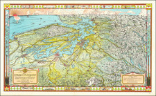
Stock# 92965
Description
Detailed U.S. Coast and Geodetic Survey sea chart of Puget Sound from Seattle to Skagit Bay.
The chart shows most of Seattle, cutting off some of south Seattle and Mercer Island. Lake Washington is shown with Medina and Eastland as very small communities on the eastern edge. References to other specific charts are made. Most of Bainbridge Island is illustrated, as is most of Whidbey Island.
Condition Description
Banding of toning at the top edge. Purple seller's ink stamps for "Lowman & Hanford Co." Closed edge tear at the bottom of the chart.
![[ Port Madison Indian Reservation - West Port Madison ] 1907 Kitsap County Atlas Township 26 North, Range 2 East, W.M.](https://storage.googleapis.com/raremaps/img/small/101544.jpg)