|
||

|

|
|

|
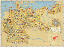
This unusual map, repurposed from obsolete tomato soup label paper, was published during World War II by the Kent Messenger. It documents the locations of V-1 rocket landings, also known as "Doodle-bugs," throughout Kent County. The map visually conveys the impact of these bombings on the region and highlights the efforts of the local population to adapt and contribute to the war effort through the creative reuse of materials.
The map's purpose was not only informative but also philanthropic, as it was sold for 6d (sixpence), with all proceeds going to service charities. It was reprinted from the "Kent Messenger" issue of September 15th, 1944.
The bombing started in June 1944 and would have been in its third month by the time this map was published. V-1s were the first of the series of "vengeance weapons" used after allies landed in France, and were the first effective cruise missiles. With the Battle for Britain having been won four years earlier, this development represented a renewal of attacks on British shores. V-1 rockets were particularly feared due to their indiscriminate nature and random targeting.
Kent is shown with hundreds of V-1 bombing sites marked, mostly in the southeastern part of the county. Fortunately, most of this area, especially the Kent Downs, is sparsely populated with respect to most of the UK. However, larger cities and towns such as Tunbridge Wells, Sevenoaks, and Maidstone are also shown to have been hit hard. Hundreds of V-1s were brought down in the Channel through the efforts of the RAF and are shown in the map.
Maps like these may have helped the Germans increase the accuracy of the V-1s. Notorious for undershooting London, British intelligence tried to convince Germany that V-1 rockets were in fact overshooting the city. As all German agents in Britain had been turned by this point, the news media diffused through neutral countries was the only way for the German army to correct their trajectories. However, this was likely a moot point as the bombing of London would stop in October as launch stations in range of the city were overran. The bombing of Antwerp would continue in force.
This map portrays a particularly difficult time for civilians in the UK. Hundreds of bombs crashed through the southern part of the country daily. This is recorded in the local area as craters which scatter the woodlands of Kent, as well as in the cultural memory of Britons and Americans stationed in Britain, as depicted in the novel Gravity's Rainbow.