


|
||

|

|
|

|
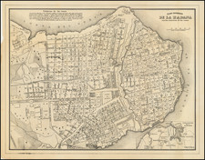
First State of a Cuba Rarity -- One of the Earliest Printed Maps of Havana
Rare first state of Thomas Milton's map of Havana, engraved by James Mynde in London.
Milton's work is one of the earliest plans of Havana, published at the beginning of the War of Jenkin's Ear (1739-1748). The plan is quite detailed with soundings given throughout the harbor. A key identifies 29 important sites, including Morro Castle, the Custom House, the Governor's Fort, the Jesuit's College, the Soldier's Barracks, the Marketplace, the English Factory, St. Diego Hospital, and numerous churches and convents.
The present example is an early state, with two major differences from the later state. First, it is not heavily embellished with topography and ships, etc. But perhaps more notably, it has significant differences in the course and location of virtually all of the rivers feeding into Havana harbor, suggesting that this early state may have been revised with additional or different sources for the later state of the map, which includes a publication date of 1739.
By the 18th century, Havana was becoming a central point for Spanish shipping in the New World. It was a major trading center for the Spanish and Havana had facilities where ships could be refitted. By 1740, it had become Spain's largest and most active shipyard and only drydock in the New World. Havana was the major city of Cuba and an important port in the Spanish Flota system, which organized all trade between Spain and its colonies in the Americas and Asia.
The majority of the fighting between Spain and Britain took place in New Granada and the Caribbean Sea, including unsuccessful British attacks on Havana and Cartagena in 1741. While the British did invade Cuba in August 1741 at Guantanamo Bay, after a number of months where the forces made very little progress under the command of Major General Thomas Wentworth, the British withdrew from Cuba in December 1741.
States of the Map / Rarity
We are aware of two states of the map.
- State 1: Lacks imprint information below neatline. Lacks ships and topographical imagery. While the basic contours of the bay are the same, there are significant differences virtually all of the rivers which flow into the bay, as well as some shallow water features. In at least one example in the north, the location of a village seems to have been relocated.
- State 2: Includes imprint (Published Decr. 10th 1759 and Sold by S. Harding . . . W.H. Toms ... price 1 Shilling. Colour'd 2 Shillings
- State 3: Dated 1760. Significantly revised and updated.
The map is very rare.
OCLC locates 1 example of state 1 (British Library-George III Topographical Collection) and 4 examples of state 2 (Boston Public Library, Harvard, Villanov, Biliotheque National de France). State 3 is known in a single example at the Clements Library (University of Michigan).
We note two examples at auction and in dealers catalogues in the past 40 years.
![[Havana / Cartagena] Neu und Verbesserter Plan der St. u. Hafens Havana aus der Ins. Cuba . . . 1739 [with] Neu under verbesserter lan des Hafnes non Cathaagena in America . . . 1740](https://storage.googleapis.com/raremaps/img/small/89441.jpg)
![[Cuba] Croquis de la Provincia De Puerto Principe Formado por el E. M. de la Capitania General de la Isla de Cuba ampliado y stampado en colors por el Deposito de la Guerra 1896](https://storage.googleapis.com/raremaps/img/small/33368.jpg)
![Culiacanae, Americae Regionis, Descriptio [with] Hispaniolae, Cubae, Aliarumqe Insualrum Circumiacientium Delineatio](https://storage.googleapis.com/raremaps/img/small/86114.jpg)