|
||

|

|
|

|
Stock# 92679
Description
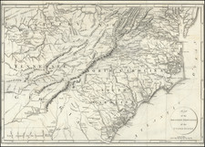
Antique engraved map of South Carolina issued by Joseph Scott in 1795.
This is one of the earliest obtainable American maps of South Carolina.
The state is divided into 9 districts. The Ninety-Six and Cheraw districts are outlined, but not named. Some counties are shown.
The Tugaloo River is spelled "Tugelo".
Condition Description
Repaired fold split. Top margin extended.
![South Carolina and Parts Adjacent; Showing The Movements of the American and British Armies [from Ramsey's History of the Revolution in South Carolina]](https://storage.googleapis.com/raremaps/img/small/83798.jpg)
![North and South Carolina [with plan of Charleston]](https://storage.googleapis.com/raremaps/img/small/103044.jpg)