


|
||

|

|
|

|
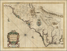
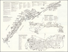
A Fine 18th Century Map of the Southern United States & Florida with Early Plans of Charleston and St. Augustine
Laurie & Whittle's edition of this scarce map of the Southern States and Florida, originally compiled by Bernard Romans for the American Military Pocket Atlas, the primary atlas carried into battle by British Officers during the American Revolution. The map extends north to the Carolinas and the confluence of the Ohio & Mississippi Rivers and is based primarily upon the surveys of de Brahm, Collet, Mouzon and the contemporary hydrographical surveys of the coast of Florida by Bernard Romans.
The map includes plans of the Charleston, South Carolina and St. Augustine, Florida.
The American Military Pocket Atlas, commonly known as the Holster Atlas, was a 6 map pocket atlas created for use by British Military Officers during the American Revolution. It includes insets of Plans of St. Augustine and Charleston. The map is probably most noteworthy for its inclusion of details along Coastal Florida, derived from the Hydrographic Surveys of Bernard Romans between 1771 and 1773, one the important pre-Revolutionary War surveys of the region.
Includes excellent detail and interesting notes throughout the map. The notes on Indian Tribes and Villages are also excellent. Shows early roads, towns, forts, rivers, mountains, mining regions, islands and a host of other details. Six precincts (counties) named in South Carolina.
An essential map for collectors of the region, bringing together for the first time the surveys of de Brahm, Collet, Mouzon and Romans in a single map.
Laurie & Whittle
Robert Laurie (ca. 1755-1836) and James Whittle (1757-1818) formed their Fleet Street, London-based firm upon the 1794 death of their employer Robert Sayer, himself one of the dominant print and mapmakers of the last half of the 18th century.
Laurie & Whittle started managing Sayer's business as early as 1787. They took over all managerial duties when Sayer's health flagged in 1792, and they changed the imprint in 1794 upon his death. Sayer left the two a 21-year lease on the shop (at £100 a year) and on Sayer's Bolt Court premises, as well as an option to acquire stock and equipment at a preferential price of £5,000 payable over three years.
Robert Laurie retired from the firm in 1812, and his role was assumed by his son, Richard Holmes Laurie (1777-1858). The younger Laurie worked with James Whittle until the latter died in 1818. After R. H. Laurie died in 1858, Alexander George Findlay, FRGS (1812-1875) purchased the firm from his daughters. The firm continues today under another name, specializing in yachting charts.
Laurie & Whittle were prolific print and map publishers, and throughout their careers, they produced numerous very important and rare works. They carried on Robert Sayer's atlas business and were responsible for editions of The Complete East-India Pilot and The American Atlas.
A General Atlas, Describing the Whole Universe [1797]
This map comes from Thomas Kitchin's A General Atlas. This atlas was conceived of by Thomas Jefferys in the 1760s. Following Jefferys' bankruptcy in 1766, the atlas was first completed by Robert Sayer in 1773. This was Robert Sayer's first terrestrial atlas. From 1794 the atlas was published by his successors Laurie & Whittle. Later editions tend to be more desirable. Thomas Kitchin's name appears on title pages even after his death in 1784. The maps are after a variety of makers such as d'Anville, Roberts, Dunn, Rocque, Delarochette, Rennell, Zannoni, Dury, Cook, Vancouver, Perouse and others.
This map is from the 1797 edition of the atlas. This atlas was later expanded and replaced by Laurie & Whittle's A New Universal Atlas.
Richard Holmes Laurie (1777-1858) was the son of mezzotint engraver Robert Laurie, who had taken over Robert Sayer's publishing house with James Whittle in 1794. Richard Holmes Laurie joined in a partnership with Whittle when his father retired in 1812. The name of the firm then switched from Laurie & Whittle to Whittle & Laurie. Whittle died in 1818, leaving Richard Holmes to continue publishing alone as R. H. Laurie.
When the Hydrographic Office opened in 1795, it was tasked with creating and producing all the nautical charts for the Royal Navy so as to wean the Navy off dependence on foreign charts. By the 1820s, private publishers were augmenting HO charts and competing with them, including Richard Holmes Laurie. Richard gave up publishing anything except nautical materials by 1830. He also sold charts to Trinity House, the lighthouse and maritime safety fraternity. He died in 1858.
The firm continued to print under the name R.H. Laurie even after 1858. Later, the firm was managed by Laurie’s draughtsman, Alexander George Findlay, and, later, Daniel and William Kettle.
James Whittle (1757-1818) was a British engraver and map printer. Whittle was employed by Robert Sayer (ca. 1725-1794). Together with Robert Laurie (1755?-1836), he took on Sayer’s business when the older man died in 1794. The two traded together as Laurie & Whittle until 1812, when Laurie retired. They had specialized in sea charts and maritime atlases. Whittle then partnered with Laurie’s son, Richard Holmes Laurie, until he died in 1818.
![Charte von Den Vereinigten Staaten von Nord-America nebst Louisiana . . . 1805 [Rare 1st State of Gussefeld's Louisiana Purchase Map]](https://storage.googleapis.com/raremaps/img/small/63496.jpg)