|
||

|

|
|

|
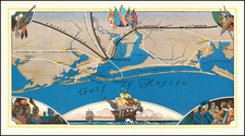
Cape Coral, Florida Real Estate Promotional Map
Pioneering Master-Planned Florida Community
With Original Letter and Photographs
A fascinating piece of Cape Coral, Florida history, an original printed real estate promotional plat map issued by the Gulf Guaranty Land and Title Company, a subsidiary of the Gulf American Land Corporation. The map is accompanied by an original typed personal letter from A. J. Martin, a resident of Cape Coral who had retired from the Bureau of Mines. The letter concerns progress in the famous development, including two original black and white photographs of a property in the development. The letter is very detailed and offers advice on reselling already purchased lots at Cape Coral, including pricing information. The recipient of the letter had apparently purchased a 3-lot canal site at Cape Coral.
The map is styled "Cape Coral Division, Allocation Map #57" and was originally issued to clients to indicate the zone in which their lots were located within the entire subdivision. Most of the lots front man-made canals. The present example has been annotated in ink with information about canal progress, and other progress relating particularly to Block 574.
The single-spaced, double-sided letter from A. J. Martin is addressed to a Dr. Worsley, and concerns recent developments in Cape Coral, including pricing details and two original black and white snapshots of a section of the development.
Excerpt from the letter hear follows:
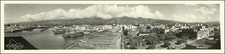
After receiving your letter on the 13th, I rode my bicycle up to Block 574, taking along an old Brownie camera. However, the pictures I got show very little except the general lay of the land. It happened that the surveyors were at work right about where your lots are. The location on the enclosed snapshot is indicated by an arrow. The long white streak at the upper left hand corner of the picture is the sand piled up digging the canal that will run along the northern edge of Block 574....
With regard to Gulf American Land Corp. fulfilling its obligations, it has done so beyond expectations. There is no development in Florida that exceeds it in growth and planning....
As you know, I have been completely retired, with no official connection with Cape Coral developers since Apr. 1, 1960, and therefore my remarks are simply those of a resident. This is an ideal place for people my age... The Yacht Club is a showplace for all Florida....
Property values are above the Map Prices on Cape Coral Parkway, that is, business properties...A house on a 3-lot homesite across the canal from my house recently sold for $22,500.00. This is a Madrid model, built at $13,000.00 price.
If I were in your place, I certainly would not consider placing your lots in anybody's hands for sale until they are developed... The resale real estate men here are much interested in developed lots, but not in undeveloped ones...
...I think Cape Coral property, and especially a 3-lot canal site like yours, is a very valuable asset, and I am sure that you will be able to sell it at a good profit as soon as the developers have completed the improvements...
Master-Planning and Dinner-Party Marketing
Cape Coral was founded in 1958 by brothers Leonard and Jack Rosen, who initially purchased a 103-square-mile tract of land on Redfish Point, across from the Caloosahatchee River, near Fort Myers. The developers pioneered a novel "dinner-party model" team-selling technique that involved offering free dinners to prospective clients. A highly trained sales team pushed to close deals within 90 minutes. By 1963, the date of the present map and letter, the population of Cape Coral was 2,850 and 1,300 buildings had been finished or were under construction. Eighty miles of roads had been built, and 160 miles of canals had been dug.
Rarity
Such original ephemeral items from Cape Coral's early days are quite rare in the market.

![[Original photograph] Native Americans, possibly Creeks, in outdoor camp with white settlers or Indian Agents.](https://storage.googleapis.com/raremaps/img/small/78740.jpg)
![(Santa Fe, New Mexico Photograph) From Francisco Street, Up [Original cabinet card photograph of Santa Fe, New Mexico street]](https://storage.googleapis.com/raremaps/img/small/92949.jpg)