This item has been sold, but you can enter your email address to be notified if another example becomes available.


|
||

|

|
|

|
Stock# 92556
Description
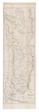
Fine original vintage map of the roads east of Portland, Oregon as they stood in the 1930s.
The map shows the Mt. Hood Loop, alongside mile markers and detailed topography. An inset in the lower left shows Portland in greater detail.
The Mt. Hood Loop was completed around 1920 and provided a loop option for the Columbia River Highway between Portland and Hood River, going by Mt. Hood.
The name A.P. Neyhert appears the bottom right. Neyhert was active in the 1930s with the Automobile Club.
Condition Description
Folding map. Minor fold toning. Faint manuscript 1938 date.