This item has been sold, but you can enter your email address to be notified if another example becomes available.


|
||

|

|
|

|
Stock# 92541
Description
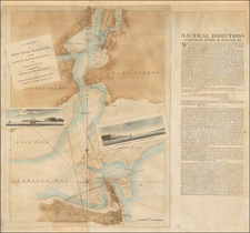
A Proposed Canal Around Niagara Falls
Regional mapping and detail images for a proposed artificial harbor meant to allow commercial shipping to make its way around Niagara Falls and thereby transit between the western Great Lakes and the St. Lawrence River.
The chart shows a proposal for building a canal around Niagara Falls to allow shipping from Lake Erie to Lake Ontario.
The topography is precisely presented with insets:
- Harbor at Four Mile Creek
- Nap of the Great Lakes taken from Tanner's map of the U.S.
- Chart of the Niagara River near the falls
- Bird's-eye view of the region showing the elevation change the canal would traverse.
Though the canal was never built, this map is a great example of American engineering design and mapmaking in the early part of the nineteenth century.
Condition Description
Minor foxing.

![[ Bennington, Vermont ] Position of the Detachment under Lieut. Col.l Baum, at Walmscock near Bennington Shewing the Attacks of the Enemy on the 16th. August 1777. Drawn by Lieut.t Durnford Engineer. Engraved by Wm. Faden 1780](https://storage.googleapis.com/raremaps/img/small/98001.jpg)