|
||

|

|
|

|
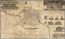
An Unrecorded State of the Second Map of Albany
Nice example of this unrecorded 1838 state of Evert Van Alen's rare map of the City of Albany, first published by Van Alen in 1818.
The present map of Albany is the second printed map of the capital of the State of New York and the first wall map of the City, preceded only by a single sheet map published by Simeon De Witt in 1794. Hand colored by wards, the map captures the remarkable growth of the city in the early part of the 19th Century, accelerated by the construction of the Erie Canal and Robert Fulton's Steamboat line between New York City and Albany, which launched in 1807.
The map also notes the Village of Green Bush across the Hudson River, connected by the Green Bush Ferry and the large Hudson River Basin opposite Van Renselaer's Island, with a key locating over 40 points of interest, irregularly located with numbers and letters, including the Jail (misspelled Goal) at Eagle and Howard Streets.
Of particular note on the map are the 11 Engine Numbers listed on the map, noting the location of the city's fire houses, including 2 Hook & Ladder locations (one conveniently shown on Water Street).
Mapping Albany
Modern-day Albany originated from Fort Orange; a Dutch trading post founded in 1614 near where the Mohawk meets the Hudson River. The English took over in 1664 when they captured New Netherland, but Dutch influences persisted for years. Albany became the county seat in 1683 and was chartered as a city in 1686, stretching a mile along the Hudson and 16 miles inland. Its location brought both trade profits from furs and vulnerability to attacks, necessitating defenses until the 1760s. In 1797, Albany was named the state capital, and its growth accelerated with the Erie Canal's completion in 1825.
Simeon De Witt, the New York State Surveyor General and an Albany resident, drafted a manuscript map of Albany in 1790. It depicted Albany as a Dutch settlement along the Hudson. In 1794, he was commissioned to design a more expansive city plan. His second map illustrated Albany stretching west from the Hudson. Titled A Plan of the City of Albany Surveyed at the Request of the Mayor, Aldermen, and Commonality, De Witt's map outlined a grid of streets not yet built, anticipating Albany's expansion. Constructed with northwest at the top of the map, proposed expansions for the city used a grid layout, with streets in the west named after animals and the south showing “The Pastures,” then communal grazing land. This map acted as a blueprint for the city's development, similar to the grid system used later in New York City and across the U.S. for urban and rural land distribution.
As Albany grew into is projected grid, the next map of Albany was published in 1818, titled Map of the City of Albany, Surveyed at the Request of the Mayor, Aldermen, and Commonality, keeping the same name as the map by Simeon De Witt. Evert Van Alen conducted the survey for this map, which displays the city’s development since De Witt’s 1794 version. This time constructed with Northeast at the top, the original grid has been expanded considerably, with the streets named for birds retained, but the streets named for animals in De Witt's 1794 map replaced by the names of prominent American heroes (and Lafayette). The first edition of the map includes a large vignette of the State Capitol Building.
The populated areas within De Witt’s previously outlined grid now show individual numbered houses, and the grid itself has expanded significantly, including ward numbers, additional streets, and blocks yet to be occupied. An update to Van Alen's map followed in 1832, which added an image of Albany's new City Hall.
Rarity
The map is extremely rare. Remarkably, the map seems only to survive in 3 examples, as noted below.
We locate the following examples:
- State 1 (1818): New York State Library and New York Public Library
- State 2 (1832): New York State Library
We note a single example of the 1818 example offered for sale in a dealer catalogue (Goodspeed, 1933).
.
![[Early Saratoga County Land Indenture] Robert C. Livingston to Daniel D'Wolf Leases](https://storage.googleapis.com/raremaps/img/small/90872.jpg)

![[Carolinas, Virginia, the Chesapeake, Pennsylvania, New York]](https://storage.googleapis.com/raremaps/img/small/71479.jpg)