|
||

|

|
|

|
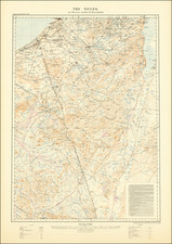
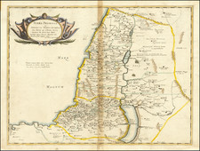
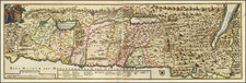
The Kingdom of Solomon
Scarce map of the Holy Land, illustrating the biblical kingdom of King Solomon as described in the Books of Judges, Kings, Chronicles, and Prophets in the Old Testament.
The map is divided into twelve regions or "eparchies," reflecting the twelve tribes of Israel, and depicts the extent of King Solomon's kingdom during his reign.
The biblical accounts of King Solomon's reign are found in the First Book of Kings and the Second Book of Chronicles in the Old Testament. According to these texts, King Solomon ruled over Israel for 40 years and was known for his wealth, wisdom, and building projects, including the construction of the First Temple in Jerusalem. During his reign, the kingdom of Israel reached its greatest territorial extent, extending from the Euphrates River in the north to the Red Sea in the south.
The "Regnum Salomonicum" map provides a visual representation of the biblical accounts of King Solomon's kingdom, offering a glimpse into the geographical and political landscape of ancient Israel. The map highlights the key cities and regions within the kingdom, including Jerusalem, the capital, and the cities of Tyre, Sidon, and Gezer. The twelve eparchies are depicted in different colors, allowing the viewer to easily distinguish between the territories of the twelve tribes of Israel.
Covens & Mortier was one of the largest and most successful publishing firms in Dutch history and continued in business for over a century. Pierre Mortier the Elder (1661-1711) had obtained a privilege in 1690 to distribute the works of French geographers in the Netherlands. After his widow continued the business for several years, Cornelis (1699-1783) took over in 1719.
In 1721, Mortier forged a partnership with Johannes Covens (1697-1774), who had recently married Cornelis’ sister. They published under the joint name of Covens & Mortier. In 1774, upon the death of his father, Johannes Covens II (1722-1794) took over his father’s share. In 1778, the company changed its name to J. Covens & Zoon, or J. Covens & Son.
Covens II’s son, Cornelis (1764-1825), later inherited the business and brought Petrus Mortier IV back into the fold. Petrus was the great-grandson of Petrus Mortier I. From 1794, the business was called Mortier, Covens & Zoon, or Mortier, Covens, & Son.
The business specialized in publishing French geographers including Deslisle, Jaillot, Janssonius, and Sanson. They also published atlases, for example a 1725 reissue of Frederik de Wit’s Atlas Major and an atlas, with additions, from the works of Guillaume Delisle. There were also Covens & Mortier pocket atlases and town atlases. The company profited from acquiring plates from other geographers as well. For example, the purchased Pieter van der Aa’s plates in 1730. Finally, they also compiled a few maps in house. At their height, they had the largest collection of geographic prints ever assembled in Amsterdam.