|
||

|

|
|

|
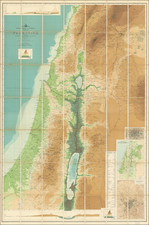
Important Early Modern Mapping of the Negev Desert
Finely executed map of the southern part of Israel and contiguous Egyptian borderlands, published by the Palestine Exploration Fund.
Extending from the Dead Sea and Gaza to just north of the Gulf of Aqaba, the map presents one of the most meticulous printed surveys of the region in the first part of the 20th Century.
The present map was the result of the surveys conducted under the leadership of Captain S.F. Newcombe of the Royal Engineers in 1913 and 1914 and printed in 1921, at the beginning of the British Mandate. Undertaken over a period of 6 weeks just before the start of WWI by Newcombe, with assistance from Leonard Woolley, and T.E.Lawrence, the expedition resulted in a remarkably comprehensive survey of the Negev Desert. The map was the first accurate scientific mapping of the region and the first to incorporate contour lines and remained the primary topographical source for the region for some time thereafter.
The present example, printed in 1921, was published as a result of the shortage of available goverment published maps in 1921 during the initial British administration of Palestine.
Palestine Exploration Fund
Founded in London in 1865, the Palestine Exploration Fund (PEF) is the first organization created specifically for the study of Palestine and the Levant. Originally created to carry out surveys of the topography and ethnography of Ottoman Palestine, the organization was established after the completion of the Ordinance Survey of Jeruslaem by Biblical archaeologists and clergy interested in the historical study of the region.
The PEF conducted many early excavations of biblical and post-biblical sites around the Levant, as well as studies involving natural history, anthropology, history and geography.
![[Jerusalem's Two Hills] Hierosolyma, Clarissima Totius Orientis Civitas Iudaee Metropolis . . .](https://storage.googleapis.com/raremaps/img/small/74099.jpg)