


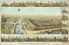
|
||

|

|
|

|
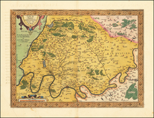
The 1772 plan of Paris presents the city during a significant period of its growth, right as the currents of the Age of Enlightenment were making their mark on Parisian intellectual and cultural life.
Central to this depiction is the newly finished Place Louis XV (late Place de la Concorde), an expansive square that would soon become an integral part of urban life. Designed by Ange-Jacques Gabriel, this space, though celebrated upon its completion, would gain a darker reputation as the backdrop for the many guillotine executions during the French Revolution.
Adjacent to this square, the meticulous details of the map capture the presence of an Assumptionist order convent and its accompanying gardens, which would soon to be replaced by the Hôtel de la Marine by 1774 (headquarters of the French Navy until 2005), marking a change in the city's architectural and urban development focus.
Bridging the Seine, several structures stood out. The Pont Neuf, despite its name meaning "New Bridge," was the city's oldest bridge, gracefully connecting the Île de la Cité to the river's banks. Other bridges, like the Pont Royal and the Pont Saint-Louis, further linked the islands to the mainland, facilitating both commerce and leisurely strolls.
Paris's green spaces were also prominently featured, with the expansive Tuileries Garden offering respite west of the Louvre. The Luxembourg Gardens on the Left Bank showcased a mix of Italian Renaissance garden design elements, while the Palais Royal and its gardens near the Louvre had become an urban hub of activity and trade.
Interspersed throughout this depiction, Paris's iconic streets were starting to hint at the grand boulevards that would dominate in the 19th century. The Seine's two natural islands, the Île de la Cité and the Île Saint-Louis, teeming with residences, churches, and civic spaces. Notably, the Gothic architectural wonder of Notre-Dame stood tall on the Île de la Cité.
Jean Lattré (fl. 1743-1793) was a Parisian bookseller and engraver who published many maps, plans, globes, and atlases. He worked closely with other important French cartographers, including Janvier, Bonne, and Delamarche, as well as other European mapmakers, such as William Faden, Santini, and Zannoni. Lattré is also interesting due to his propensity to bring suits against those who copied his work; plagiarism was common practice in eighteenth-century cartography and mapmakers struggled to maintain proprietary maps and information.
![(Paris Region) Agri Parisiensi Tabula particularis… Particulir Karte des Landes und der Schön Weltberühmte Gegend um Paris, so da ist der größte Teil des Gouvernement der Insel von Frankreich, accurat verzeichnet von F. Vivier und verlegt durch J.B. Homann. [Particular Map of the Lands and the Beautiful World-Renowned Region around Paris, which is the Greater Part of the Government of the Isle of France, accurately depicted by F. Vivier and published by J.B. Homann.]](https://storage.googleapis.com/raremaps/img/small/93947.jpg)
![[Paris - Soissons - Champagne / area between the Seine River, Oise, River, Aisne River and Marne Rivers]](https://storage.googleapis.com/raremaps/img/small/90932.jpg)
![[ Paris - Place du Roi de Rome - Place de Trocadero ]](https://storage.googleapis.com/raremaps/img/small/90032.jpg)