|
||

|

|
|

|
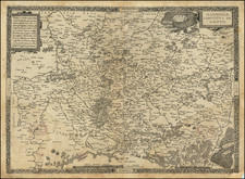
Fine, Early Manuscript Map of France
Striking map of the area between the Seine, Oise, Aisne, and Marne Rivers in an early eighteenth-century hand.
The east-oriented map shows an area now in north-central France. Several notable cities and towns are included, such as Paris and Compagnie. The area between is peppered with small towns.
The main emphasis is on waterways and settlements, with some roads. Many of the towns include numbers, which likely suggests their tax contribution. This would appear to be a bureaucratic document.
The handwriting dates the map to ca. 1650. At that time, while Louis XIV was on the throne, France was a world power with a sprawling empire. Most French people, however, lived rural, agricultural lives in and near towns like those seen on this map.
On the verso of the map, in a slightly later hand (ca. 1750), is an inscription that reads, in part, “JJ le leFranc.” Jean Jacques LeFranc de Pompignan (1709-1784) was a French savant best known for his poetry and literary criticism. He hailed from southern France. The family had a longstanding relationship of service with the Court of Aids, which oversaw customs duties and other financial matters.
This map was likely of interest to Lefranc due to his connection with the Court of Aids and was probably part of the gentleman's library. LeFranc had a library of some 25,000 volumes which were auctioned by his son after his death. They seeded the libaries of three learned institutions in Toulouse.
![[ Paris ] La Ville, Cite, Universite, & Faux-Bourgs de Paris](https://storage.googleapis.com/raremaps/img/small/103453.jpg)
![Carte du Pays et Diocese de Reims [Map of the Country and Diocese of Reims]](https://storage.googleapis.com/raremaps/img/small/67548.jpg)