


|
||

|

|
|

|
Fine Example of First Printed Map of Australia
Fine example of the first printed map of Australia, one of the rarest and most highly sought after of all early maps of the region.
The map appeared in the second edition of De Jode's rare Speculum Orbis Terrae, one of the most scarce and prized of all late-sixteenth century atlases and now virtually unobtainable on the market, especially in original color. It was issued in only one known state and edition. The map is one of two seminal maps covering the Pacific in the second edition of Speculum, the second showing the northwest coast of America.
Dominating the lower third of the map is the coastline of the continent of Australia, specifically what is now known as Queensland. This is not only the first printed map of Australia, but is also rare in that it separates New Guinea and Australia. Later mapmakers would often join the two islands. Although the text that accompanies this map reveals that De Jode isn't convinced they are separated, he chose to depict them as two entities on the map. The top two thirds of the map show the islands of New Guinea, the Solomons, and the Archipelago of San Lazaro-all three reveal the extent of Spanish exploration in the area.
Despite the geographic importance of the map, perhaps the most noticeable aspect of the work is the herd of fanciful animals and the fantastic vessels scattered across the space. Australia has a dragon, lion, and snake, as well as a hunter taking aim with bow and arrow. A mermaid and merman embrace to the east of the Solomons, while a ship is in full sail farther south. Finally, two flying sea monsters and two swimming beasts represent the dangers of the waters.
European Exploration of the Western Pacific in the 16th century
Recorded sixteenth century European maritime activity in this region must start with the circumnavigation of Ferdinand Magellan in 1519-1522. As he sailed into the islands that make up the Philippines, he named them the Archipelago of San Lazaro, here the Arcipelago di S. Lazaro, because his crew landed there on the feast day of Saint Lazarus of Bethany.
Another voyage chronicled here is that of Alvaro de Saavedra. In 1527, Saavedra was sent from Mexico by Hernan Cortes, his cousin, to discover new lands for the Spanish Crown and to locate the Trinidad, one of Magellan's squadron. He sailed for three years and in 1528 journeyed 500 miles down the northern coast of what is now New Guinea while seeking a route to New Spain; he called New Guinea the Isla de Oro, or Island of Gold. The next year, 1529, he ranged over the central Pacific in an attempt to return to New Spain, but he died en route. His crew returned west to the Moluccas. Both the coast of New Guinea and the numerous small islands along its northern coast are thanks to accounts of Saavedra's voyage.
Another vessel, under the command of the Spaniard Hernando de Grijalva, spent considerable time exploring the region. Grijalva was experienced in probing the Pacific. In the early 1530s he participated in reconnaissance missions in the eastern Pacific and off the California coast, where he helped to contact islands that would grace maps for centuries: Santo Tomas (today Socorro) and San Benedicto.
In 1535, Hernan Cortes ordered him to go to Peru to aid Francisco Pizarro. From there, Grijalva set out to explore the equatorial Pacific. He sailed widely between 20 degrees south and north, but his men eventually begged him to land at the Moluccas, the nearest known land at the time. Grijalva refused because the Moluccas were Portuguese territory according to the Treaty of Zaragoza (1529). Desperate, the crew mutinied and Grijalva was killed or died of illness soon thereafter. The survivors sailed along the coast of New Guinea and, although few accounts of this voyage exist, it is likely they had some influence on this map.
The name "Novae Guinea", or New Guinea, was coined by Spanish explorer Íñigo Ortíz de Retes in 1545, referring to his opinion that the appearance of the native peoples resembled that of the natives of the Guinea region of Africa. A note to this effect fills the interior of the island on this map.
Finally, the Isles de Salamon shown on the map owe credit to another expedition. Alvaro de Mendaña was sent to the western Pacific in search of the so-called "Isles of Fortune" rumored to have been visited by the Inca hero Tupac Yupanqui. Mendaña left Callao, Peru in 1567 and landed on the Solomons and islands farther east ( Ysabella). However, the crew encountered cannibals and they returned to Peru. Interestingly, just after this map was published Mendaña returned to the Pacific to search for the Solomons but contacted the Marquesas instead. The Solomons, whose longitude was not correctly recorded, would wander the Pacific on maps until the late eighteenth century.
These voyages, which were usually kept secret and are therefore vague in their details, resulted in the hypothetical geography put together here by de Jode. Additionally, there were rumors of Portuguese exploration along the east coast of Australia dating as far back as the 1520s. These rumors affected the Dieppe School of mapmakers who sometimes included a large, fanciful southern continent on their maps. The unlabeled Australian coast shown here resembles their imaginings. Speculation and compilation were the mapmaker's main tools, especially for a region as unknown as the Western Pacific.
The De Jode Atlas
This map appeared in the second edition, or re-issue, Gerard De Jode's atlas, Speculum Orbis Terrae (first edition Antwerp: 1578) . Gerard De Jode (1509-1591) released his atlas in a golden age of Dutch atlas production: the first atlas was released in 1570, also in Antwerp, the first town atlas in 1572, the first pocket atlas in 1577, the first regional atlas in 1579, the first nautical atlas in 1584, and the first historical atlas in 1595. The first atlas was Ortelius' Theatrum orbis terrarium, and De Jode's was intended as competition for Ortelius'. Mercator was also preparing an atlas at the time, and corresponded with Ortelius, but it would not appear in full until 1595, a year after Mercator's death.
Although the Speculum was ready as early as 1573, it was not published until 1578. This is most likely due to Ortelius' influence and his privilege over atlas publishing, which expired just before De Jode finally published. The atlas was the result of collaboration between De Jode, the geographer Jan van Schille of Antwerp, German physician Daniel Cellarius, and the etchers Joannes and Lucas van Doetecum.
Although never as successful as Ortelius' Theatrum, the Speculum did get republished in a second edition in 1593, two years after De Jode's death, by Arnold Coninx, and included this map. After his death, Gerard's son, Cornelis (1568-1600), and his wife, Paschina, ran the shop. Unfortunately, Cornelis died young in 1600, aged only 32, and the stock and plates were sold to the publisher Joan Baptista Vrients. Vrients had also recently purchased the plates for Theatrum, giving him a monopoly over Antwerp atlas publication. Vrients acquired the De Jode atlas plates only to suppress them in favor of the Ortelius plates, thus the De Jode atlas maps are quite rare on the market today. This is a particularly fine, old color example of this extraordinarily rare and important map.
Peter Barber, et al., Mapping Our World: Terra Incognita To Australia (National Library of Australia, 2013).
Thomas Suarez, Early Mapping of the Pacific (Hong Kong: Periplus, 2004).
Lawrence C. Wroth, “The Early Cartography of the Pacific,” The Papers of the Bibliographical Society of America 38, no. 2 (1944): 87-268.
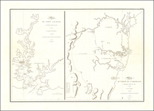

![[South Australia] Ports in the Gulf of St. Vincent and Encounter Bay Surveyed by Comr. J. Hutchinson R.N. and assisted by F. Howard & M.S. Guy Navl. Lieutts. R.N. 1869 (Port Victor, Port Elliott, Port Willunga and Port Noarlunga)](https://storage.googleapis.com/raremaps/img/small/38744.jpg)