|
||

|

|
|

|
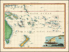
The Wilkes Expedition and the Charting of Vanua Levu’s Northern Channel
The Wilkes Expedition, officially known as the United States Exploring Expedition, was an ambitious American scientific and exploratory voyage led by Lieutenant Charles Wilkes from 1838 to 1842. With its diverse team of scientists, artists, and sailors, the expedition aimed to explore and survey the Pacific Ocean and surrounding lands, thereby asserting the young nation's interests in the Pacific region.
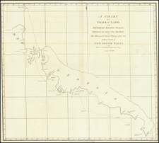
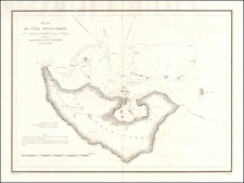
Channel on the North Side of Vanua Levu: An Insight into Fijian Coastal Topography
One of the charts produced during this expedition is the "Channel on the North Side of Vanua Levu from Muthuata Island to Ivaca Peak, Feejee Islands". This detailed coastal chart provides an unparalleled insight into the topography of the northern side of Fiji's second-largest island, Vanua Levu.
The neighboring islands of Anganga, Naloa, Vavea, Anutunga, Naumbutha, Vaungili, Nuvera, Vatou, and others punctuate the seascape around Vanua Levu. Each of these islands contributes uniquely to the maritime significance of the region, acting as navigational markers, providing potential anchorage spots, and creating a diversified marine ecosystem.
Crucially, the chart delineates the treacherous reefs and shallow waters surrounding Vanua Levu – vital information for any vessel navigating these waters. The reefs, acting as both a hazard and a protectorate for the islands, play an essential role in the region's ecology, supporting a diverse array of marine life.
The ship channel is meticulously detailed, with extensive soundings indicating the depth of the waters. This would have been invaluable for the ships of the time, ensuring they navigated safely while approaching or skirting the island. The naming of several mountains, such as Ivaca Peak, adds another layer to the chart, offering navigational landmarks and providing a terrestrial perspective to the coastal view.
The Wilkes Expedition's Encounter with Vanua Levu
During his time in the Fijian waters, Wilkes and his crew charted numerous islands, channels, and coastal features. Their meticulous documentation of the region's geography was groundbreaking, offering Westerners a comprehensive view of an area previously shrouded in mystery and misinterpretation. Their encounters weren't always peaceful, though; the Fijian archipelago was known for its warrior culture, and on occasion, Wilkes' crew clashed with local inhabitants.
Despite these challenges, the Wilkes Expedition's time in the region was instrumental in broadening Western understanding of the Pacific and its many diverse islands, peoples, and ecosystems. The chart of the Channel on the North Side of Vanua Levu stands as a testament to the expedition's dedication to scientific rigor, exploration, and the advancement of maritime knowledge.
In conclusion, the Wilkes Expedition's endeavors around Vanua Levu and its resulting charts are emblematic of the 19th-century spirit of exploration and discovery. They capture a moment when the vast Pacific, with its myriad islands and cultures, was slowly being unveiled to the Western world.
Charles Wilkes (1798-1877) was a skilled naval surveyor and the commander of the United States South Seas Exploration Expedition (U.S. Ex. Ex.), the largest scientific voyage ever mounted by the United States. Wilkes was born in New York City and began to sail in merchant vessels from 1815-1917.
Wilkes joined the United States Navy as a midshipman in 1818; by 1826, he had risen to the rank of lieutenant. Fascinated by hydrography, Wilkes studied triangulation and surveying with Ferdinand Hassler, the first superintendent of the United States Coast Survey. This expertise and initiative led him to be named Director of the Navy’s Depot of Charts and Instruments in 1833.
After being stalled by the Navy, U.S. Ex. Ex.—the U.S. response to the scientific voyages of Cook and La Perouse—was finally preparing to sail in the late 1830s. Wilkes was offered command, thanks to the heavy surveying focus on the voyage. He was given command of six vessels and nine scientists. However, the ships were not well supplied and the expedition was executed with some difficulty.
The ships left Norfolk in August 1838. They went in convoy to Tierra del Fuego, where they split and some explored in the South Seas and others in the South Atlantic. In late 1830, Wilkes surveyed portions of Antarctica that today are named for him (Wilkes Land). From spring 1840, the ships explored the mid- and North-Pacific. In June 1842, Wilkes returned to New York Harbor with only two of his six ships and a mountain of ethnographic, botanical, and natural historical specimens, as well as reams of observations, drawings, and charts.
Wilkes was met with a court martial; while he was acquitted of most charges, he was convicted of illegal punishment and reprimanded by the Secretary of the Navy. Despite this, he was promoted commander in 1843, captain in 1855, and commodore in 1862.
Wilkes spent much of his remaining career overseeing the publications of the expedition. The first official publication to appear was Wilkes’ rambling five-volume narrative of the voyage, accompanied by a folio atlas, in 1844. A further 19 volumes were prepared over the course of 30 years, each on a different scientific topic, although only 14 were ever distributed. Perhaps the most impressive legacies of the expedition were the almost 250 charts Wilkes prepared in two atlases (completed 1858, published 1861, but not distributed until after the Civil War). These formed the basis of the United States Hydrographic Office.
Wilkes served in the Union fleet in the Civil War. In 1864 he was before a court-martial again, this time for the publication of a private letter to the Secretary of the Navy. He was found guilty. He retired two years later, in 1866, and died in Washington D. C. in 1877.