|
||

|

|
|

|
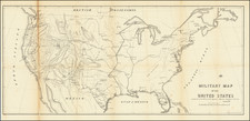
Scarce 1852 state of this decorative wall map of the United States, published by Phelps, Ensign & Thayer.
The map provides a nice snapshot of the United States on the eve of the Gadsden Purchase (1853-54) and the creation of Washington Territory (March 2, 1853). The gold regions of California are shown (in gold), with a massive Utah Territory and New Mexico Territory, predating the creation of Nevada, Arizona and Colorado.
In the north, Oregon Territory still subsumes all of the future Washington and Idaho, with a massive Nebraska Territory shown, pre-dating the creation of Kansas, Wyoming, Montana and Colorado. The map also pre-dates the creation of Dakota Territory (1861), with a massive Minnesota Territory shown.
The map is surrounded by decorative elements, illustrating the history of the United States, including a large vignette of the signing of the Declaration of Independence, portraits of presidents, important naval battles and other historic scenes, including recent views of from the Mexican War. Finished with a population table and a key at the bottom, showing the names (and signatures) of the signers of the Declaration of Independence.
The map was first issued in 1847 and updated annually until the middle of the 1850s.
![A Map of Lewis and Clark's Track Across the Western Portion of North America, from the Mississippi to the Pacific Ocean. By Order of the Executive of the United States in 1804, 5 & 6. . . . [Complete with 3 volumes of Text: Travels to the Source of the Missouri River and Across the American Continent to the Pacific Ocean. Performed by Order of the Government of the United States, in the Years 1804, 1805, and 1806].](https://storage.googleapis.com/raremaps/img/small/81775.jpg)
![[ Southern Railroads ] Railroad Map of the Southern States Shewing the Southern & Southwestern Railway Connections With Philadelphia. 1862 . . . Prepared by Thomas Kimber Jr., Chairman of the Committee on Inland Transportation of the Board of Trade of Philadelphia](https://storage.googleapis.com/raremaps/img/small/103211.jpg)