|
||

|

|
|

|
Stock# 91757
Description
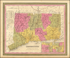
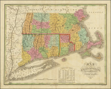
Detailed and interesting map of Connecticut, hand colored by county and showing towns, rivers, bays, lakes, railroads, roads, distances, etc.
Tables of populations by county and showing growth of population since 1701.
A nice example of this increasingly difficult to obtain pre-Civil War map.
Insets of Hartford and New Haven.