|
||

|

|
|

|
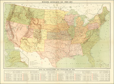
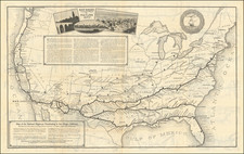
Map of the Erie Railway and Connections produced by Rand, McNally & Co., Engr's of Chicago offers a detailed perspective of the extensive railroad network that proliferated in America during the late 19th century. Accompanying this primary portrayal is an inset titled Around the World, Across the American Continent via Erie Railway, showcasing the global vision of the railway company during this time of accelerated growth in international transport.
Established formally in 1861, the Erie Railway was one of the significant railroads instrumental in driving America's westward expansion and industrial advancement in the late 19th century. The Map of the Erie Railway and Connections, crafted by the esteemed Rand, McNally & Co., represents more than the physical blueprint of this railway's numerous links. It mirrors the period's transformative growth in infrastructure, indicative of the United States' shift from a largely agrarian society to a nascent industrial superpower.
The inset map, Around the World, Across the American Continent via Erie Railway, illustrates the prominent worldview of the era—global interconnectedness, advancement, and a shared aspiration towards globalization. By placing the Erie Railway within a grand, worldwide expedition, this inset map communicates the railway's ambitions, signaling an era where rail travel was seen as a potent tool for shrinking vast geographical distances.
The proficiency reflected in the construction of this map, apparent in its detail and precision, showcases the sophisticated lithographic techniques wielded by Rand, McNally & Co. As a historical document, this map captures the ascent of the United States as an industrial nation, the ambitions of its railway corporations, and the aspirations of the era for global connection and progress. It offers an opportunity for appreciation beyond the technical and industrial progress, into the wider historical milieu within which these advancements were realized.
The date was roughly estimated based on the other railways illustrated.
Rare.
Rand McNally & Co. is a large American map and navigation company best known for its annual atlases. The company got its start in 1856, when William Rand opened a print shop in Chicago. He was joined in 1858 by a new employee, Andrew McNally. Together, the men established their namesake company in 1868. Originally, the company was intended to print the tickets and timetables for the trains running to and through Chicago; their first railway guide was published in 1869.
By 1870, they had shifted from just printing to publishing directories, travel guides, and newspapers. Their first map appeared in 1872 in a railway guide. The map was produced using a new wax engraving method, a cheaper process that gave the company an edge.
By 1880 Rand McNally had entered the education market with globes, wall maps, and geography texts for students. In 1923, Rand McNally published the first Goode’s World Atlas, named after its editor, Dr. J. Paul Goode. For generations afterward, this would be the standard classroom atlas.
In 1899, William Rand left the company, but McNally and his family remained, controlling the company for over a century. In 1904, they published their first road map intended for automobiles and by 1907 were publishing Photo-Auto Guides, which combined photography and mapping to help drivers. In 1924, they produced the Auto Chum, a precursor to their famous road atlases. Rand McNally would remain the leader in road maps and atlases throughout the twentieth century.
In 1937, Rand McNally opened its first store in New York City. Ever on the frontier of technology, Rand McNally pioneered the scribing process for printing tickets in 1958 and printed their first full-color road atlas in 1960. Arthur Robinson developed his now-famous projection of Rand McNally in 1969. By the 1980s, the company was exploring digital reproduction and digital databases of maps for truckers. In the 1990s, they lead the charge to develop trip-planning software and websites. Today, most of its products are available online or in a digital format, including maps for tablets and phones.