|
||

|

|
|

|
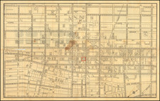
Mid-century aerial view and map of Los Angeles. The map is printed on the recto, and the view is on the verso. It is folded vertically and horizontally, as issued.
This appeared in the Library of Congress' July-December 1952 catalog of copyright registrations, with a copyright date of June 1st, 1952.
On the map, dotted lines represent rivers and creeks. Hollywood Parkway is shown as a dashed line from Sunset Boulevard to where it meets Cahuenga Boulevard. The Harbor Parkway is shown as a dashed line paralleling Figueroa from the Figueroa Street Tunnels down to Olympic Boulevard. The Santa Ana Parkway is a solid line from Aliso to Atlantic Boulevard and a dashed line to Norwalk Boulevard. The San Bernadino Freeway is still the Ramona Freeway.
Fellowship Farm, a former commune in Puente, is shown off of Glendora Ave, though it had been taken over by a water utility company in 1927.
An inset map highlights industrial areas bordering San Bernadino and Riverside counties.
Routes of the Pacific Electric and Los Angeles Railways and the Southern Pacific Union Pacific, and Atchison, Topeka, and Santa Fe Railroads are shown.
On the verso, the aerial view shows the Central Manufacturing District, between the Santa Ana Freeway, Rio Hondo, and Los Angeles River, in what is now Commerce, surrounded by Vernon, South Gate, and Downey with Glendale and Pasadena in the distance. Downtown Los Angeles is shown to the northeast.
Central Manufacturing District, Inc., was organized in 1922 by the Union Stock Yard investment group's holding company Los Angeles Corp., which also owned the Los Angeles Junction Railway Company that served the district. The corporation was bought from Eugene Thayer in 1928 by the Santa Fe Railroad, although the Los Angeles Times had speculated Thayer was a frontman for the railroad company, positing it had gained control as early as 1926.
Sutton, Robert P. Modern American Communes: A Dictionary. Westport: Greenwood Press, 2005.
Pasma, Theodore K.. Organized Industrial Districts: A Tool for Community Development. United States: U.S. Department of commerce, Office of technical services, Area development division, 1954.
Metropolis in the Making: Los Angeles in the 1920s. United Kingdom: University of California Press, 2001.