|
||

|

|
|

|
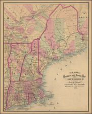
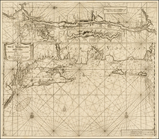
Rare French Plan of Boston Harbor Prepared During The Revolution
Rare French version of Sayer & Bennett's important charting of Boston Harbor, which has been revised and issued for use by the French Navy, published separately and included in Le Rouge's Pilote Americain Septentrionale, a sea atlas compiled specifically for use by the French Navy during the American Revolution.
Ideally constructed for navigational purposes, with an exceptionally fine eye toward practical navigation, the chart includes extensive soundings, Boston Harbor's many hazards are marked, and specific courses and sailing directions are provided for navigating the difficult waters. For example, accessing the "best channel" for the final approach to Boston requires one to sight on the "Charlestown Tree" situated on or near Breed's Hill. On land, there is a full street plan of Boston with several landmarks indicated, while the towns of Dorchester, Milton, and Hull are shown schematically. To the northwest are the "Ruins of Charlestown," indicating that the chart was completed sometime after the June 1775 Battle of Bunker Hill.
The chart includes a note following the title the chart was based on contemporary British surveys. The primary source would by Sayer & Bennett's chart of Boston Harbor, which was published separately and included in the extremely rare North American Pilot, the chart depicts Boston Harbor from roughly Deer Island to Hull. While issued at about the same time as Des Barres chart of Boston Harbor, Sayer & Bennett's chart provides a much more pragmatic and utilitarian approach to navigation in Boston's tricky waters. The chart places its greatest emphasis on local details and practical sailing directions, unlike the Des Barres chart, which places far greater emphasis on topography, but is almost completely silent on practical guides for navigation, other than basic guidelines, relying on a separate sheet for sailing directions.
On land there is a full street plan of Boston with several landmarks indicated, while the towns of Dorchester, Milton and Hull are shown schematically. To the northwest are the “Ruins of Charlestown,” indicating that the chart was completed some time after the June 1775 Battle of Bunker Hill.
Rarity
The Le Rouge edition is better-engraved than the Sayer & Bennett edition and rarer on the market. This is the second example we have offered for sale in the past 25 years.
George-Louis Le Rouge (1712-1790), though known for his work in Paris, was originally born Georg Ludwig of Hanover, Germany. He grew up and was educated in Hanover, after which he became a surveyor and military engineer. Around 1740, however, Le Rouge moved to Paris and set up shop as an engraver and publisher on the Rue des Grands Augustins. It was at this time that he changed his name, adopting a French pseudonym that would later become quite famous.
Le Rouge spent much of his forty-year career translating various works from English to French, and his cartographic influence often came from English maps. His experience as a surveyor and engineer in Germany made him a skilled and prolific cartographer, and he produced thousands of charts, maps, atlases, and plans. His work spans from garden views and small-town plans to huge, multiple-continent maps. Le Rouge eventually accepted the position of Geographical Engineer for Louid XV, the King of France.
Later in life, Le Rouge became well-known for publishing North American maps, such as in his Atlas ameriquain septentrional of 1778. One of Le Rouge’s other more famous works is the Franklin/Folger chart of the Gulf Stream, which he worked on with Benjamin Franklin. Franklin and Le Rouge corresponded around 1780 and collaborated to create this map, a French version of Franklin’s famous chart which was originally printed in 1769.
![( South Carolina Manuscript Plat Map ) [Land grant document signed by Revolutionary War hero William Moultrie with plat map signed by surveyor general Peter Bremar and deputy surveyor David Reynolds] State of South-Carolina. To all to whom these presents shall come, greeting... by these Presents do grant unto the said Harmon Dees ... a Plantation or Tract of Land, containing Four Hundred Acres situate in the District of Camden on Polly Bridge Swamp waters of Black River](https://storage.googleapis.com/raremaps/img/small/84439.jpg)