|
||

|

|
|

|
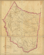
South Carolina Plat Map and Land Grant Deed Signed by Revolutionary Hero William Moultrie
Governor of South Carolina for whom Fort Moultrie is named
The plat map describes a 400-acre tract near Camden, South Carolina, granted to Harmon Dees (1743-1807), a native of North Carolina. These lands were situated in "the District of Camden on Polly Bridge Swamp waters of Black River." The map notes several interesting features concerning the surrounding area such as the location of the swamp waters and a pole bridge, as well as the names of neighboring land owners: Isaac Huger, Esqr.; land supposed to be laid out for Richard Bradford; Ruth Dees' land; land laid out for Jacob Dees (Harmon's brother). The nicely printed land grand deed has a decorative printed border and was completed in manuscript at Charleston, South Carolina on Feb. 5, 1787.
Below the neatly delineated manuscript plat map is the following text:
South Carolina
I have caused to be admeasured & laid out unto Herman Dees a Tract of Land containing Four Hundred acres ... District of Camden on Polley Budge Swamp Waters of Black River, & all such form marks, Buttings & Boundings as the above Plat represents.
Certified for the 30th day of August, 1786,
Peter Bremar, Surveyor General
David Reynolds, Deputy Surveyor
William Moultrie has boldly signed his name and rubric, on a smaller sheet of paper which is tied to the printed deed with a textile ribbon. At the time of this land grant, Moultrie was serving the first of his two terms as Governor of South Carolina.
Hero of the American Revolution
Moultrie had an illustrious and outstanding career during the American Revolution. In 1775 he was commissioned as colonel of the Second South Carolina Regiment of provincial troops. The following year Moultrie's defense of a small fort on Sullivan's Island (later named Fort Moultrie in his honor) stopped Sir Henry Clinton and Sir Peter Parker from taking Charleston at that time. The Continental Congress acknowledged Moultrie with an official resolution of thanks. Promoted to brigadier general, his regiment was taken into the Continental Army.
Moultrie successfully repulsed the British at Port Royal in February 1779. That spring when Major General Benjamin Lincoln took the bulk of the American force towards Augusta, Georgia, Moultrie was stationed at Black Swamp with a small contingent to watch the British on the other side of the Savannah River. When the British suddenly crossed the Savannah en masse and tried to move on Charleston, Moultrie managed a skillful tactical retreat across the Coosawhatchie and the Tulifiny Rivers and all the way back to Charleston where he held off a short siege. He refused to surrender at a time when other South Carolina leaders were almost ready to give up.
May 1780 brought the American Revolution to Charleston, South Carolina when it fell under the Crown's control. Lord Charles Cornwallis and 2,500 of his Loyalist and British troops marched to Camden and established there the main British supply post for the Southern campaign. soldiers led by Lord Francis Rawdon. The latter battle was a costly win for the British and forced them to leave Camden and retreat to the coast.
The Battle of Camden, the worst American defeat of the Revolution, was fought on August 16, 1780, near Camden, and on April 25, 1781, the Battle of Hobkirk's Hill was fought between about 1,400 troops led by General Nathanael Greene and 950 Loyalists and British Troops.