


|
||

|

|
|

|
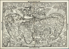
De Fer’s Instructive Model of the World
Informative, striking double-hemisphere map of the world by De Fer, part of a larger geographic broadside.
The map includes a geographic text, as well as models of armillary spheres and wind roses that include the names for the winds in the Mediterranean and the Atlantic.
The document is dedicated to “les enfans de France,” or the children of France. The crest of the French Royal family, with its three fleur-de-lis on a blue background, indicates a nod to royal patronage as well. When the map was first published, in 1705, the succession to the Crown was quite complex, due to the longevity of Louis XIV. It was initially the Dauphin, the only surviving legitimate son of the King. He died in 1711. The next year, the Dauphin’s own son, the Duke of Burgundy, also died, followed by Burgundy’s son. This left Louis, the younger son of Burgundy, as the heir to the throne when the Sun King passed in 1715.
This map is intended as a teaching aid to communicate basic geographic principles like the antipodes, equator and tropics, and climactic theory. The latter is explained in the western hemisphere, where notes define frigid, temperate, and torrid zones.
Even so, there are some interesting cartographic details, mainly that California is shown as an island. North America’s northern coast is unfinished, as is the eastern coast of Asia and some Pacific islands. This is due to a lack of European experience with the area. There is no southern continent or Australia, a conservative approach characteristic of French academic geographers at this time.
This example also includes a manuscript addition of “NTA” near the Antarctic Circle.
Rarity
The map is rarely seen on the market. AMPR notes two prior examples (Loeb-Larocque Auction, 2005) and Kit S. Kapp (1994).
The popular misconception of California as an island can be found on European maps from the sixteenth through the eighteenth centuries. From its first portrayal on a printed map by Diego Gutiérrez, in 1562, California was shown as part of North America by mapmakers, including Gerardus Mercator and Abraham Ortelius. In the 1620s, however, it began to appear as an island in several sources. While most of these show the equivalent of the modern state of California separated from the continent, others, like a manuscript chart by Joao Teixeira Albernaz I (ca. 1632) now in the collection of the National Library of Brasil shows the entire western half of North Americas as an island.
The myth of California as an island was most likely the result of the travel account of Sebastian Vizcaino, who had been sent north up the shore of California in 1602. A Carmelite friar, Fray Antonio de la Ascensión, accompanied him. Ascension described the land as an island and around 1620 sketched maps to that effect. Normally, this information would have been reviewed and locked in the Spanish repository, the Casa de la Contratación. However, the manuscript maps were intercepted in the Atlantic by the Dutch, who took them to Amsterdam where they began to circulate. Ascensión also published descriptions of the insular geography in Juan Torquemada’s Monarquia Indiana (1613) (with the island details curtailed somewhat) and in his own Relación breve of ca. 1620.
The first known maps to show California as an island were on the title pages of Antonio de Herrera’s Descripción de las Indias Occidentales (1622) and Jacob le Maire's Spieghel Der Australische Navigatie (1622). Two early examples of larger maps are those by Abraham Goos (1624) and another by Henry Briggs, which was included in Samuel Purchas’ Hakluytus Posthumus or Purchas his Pilgrimes (1625). In addition to Briggs and Goos, prominent practitioners like Jan Jansson and Nicolas Sanson adopted the new island and the practice became commonplace. John Speed’s map (1626-7), based on Briggs’ work, is well known for being one of the first to depict an insular California.
The island of California became a fixture on mid- and late-seventeenth century maps. The island suggested possible links to the Northwest Passage, with rivers in the North American interior supposedly connecting to the sea between California and the mainland. Furthermore, Francis Drake had landed in northern California on his circumnavigation (1577-80) and an insular California suggested that Spanish power in the area could be questioned.
Not everyone was convinced, however. Father Eusebio Kino, after extensive travels in what is now California, Arizona, and northern Mexico concluded that the island was actually a peninsula and published a map refuting the claim (Paris, 1705). Another skeptic was Guillaume De L’Isle. In 1700, De L’Isle discussed “whether California is an Island or a part of the continent” with J. D. Cassini; the letter was published in 1715. After reviewing all the literature available to him in Paris, De L’Isle concluded that the evidence supporting an insular California was not trustworthy. He also cited more recent explorations by the Jesuits (including Kino) that disproved the island theory. Later, in his map of 1722 (Carte d’Amerique dressee pour l’usage du Roy), De L’Isle would abandon the island theory entirely.
Despite Kino’s and De L’Isle’s work, California as an island remained common on maps until the mid-eighteenth century. De L’Isle’s son-in-law, Philippe Buache, for example, remained an adherent of the island depiction for some time. Another believer was Herman Moll, who reported that California was unequivocally an island, for he had had sailors in his offices that claimed to have circumnavigated it. In the face of such skepticism, the King of Spain, Ferdinand VII, had to issue a decree in 1747 proclaiming California to be a peninsula connected to North America; the geographic chimera, no matter how appealing, was not to be suffered any longer, although a few final maps were printed with the lingering island.
Nicholas de Fer (1646-1720) was the son of a map seller, Antoine de Fer, and grew to be one of the most well-known mapmakers in France in the seventeenth century. He was apprenticed at twelve years old to Louis Spirinx, an engraver. When his father died in 1673, Nicholas helped his mother run the business until 1687, when he became the sole proprietor.
His earliest known work is a map of the Canal of Languedoc in 1669, while some of his earliest engravings are in the revised edition of Methode pour Apprendre Facilement la Geographie (1685). In 1697, he published his first world atlas. Perhaps his most famous map is his wall map of America, published in 1698, with its celebrated beaver scene (engraved by Hendrick van Loon, designed by Nicolas Guerard). After his death in 1720, the business passed to his sons-in-law, Guillaume Danet and Jacques-Francois Benard.
![[Part of Orange County] Anaheim Quadrangle](https://storage.googleapis.com/raremaps/img/small/83489.jpg)
![[ California To Alaska -- Northwest Passage ] Quivirae Regnu cum alijs versus Borea](https://storage.googleapis.com/raremaps/img/small/60083.jpg)