


|
||

|

|
|

|
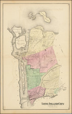
Original antique map of the Queens neighborhood of Astoria, on Long Island, from Beers's Long Island Atlas, published in 1873.
The map is brilliantly detailed, with landowners shown for many plots, and all major points of interest marked. Streets are named and individual buildings are shown in parts. Hallet's Cove, Hell Gate, and Way's Reef are all named.
Astoria has a rich history that dates back to the mid-1600s when it was first settled by William Hallet. It became known as Hallett's Cove, and was incorporated in 1839. The city was renamed for John Jay Astor shortly thereafter to try to encourage him to invest in the area. In the mid-1800s, Astoria was a popular destination for wealthy New Yorkers who built large estates and mansions in the area. Astoria's growth continued into the late 1800s, and by the early 1900s it had become a thriving community with a mix of residential and commercial developments. Today, Astoria is a diverse and vibrant neighborhood that is home to a large number of immigrants from around the world.


![[ New York City ] Vue de la Nouvelle Yorck](https://storage.googleapis.com/raremaps/img/small/84430.jpg)