This item has been sold, but you can enter your email address to be notified if another example becomes available.


|
||

|

|
|

|
Stock# 91031
Description
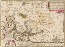
Finely executed hand drawn map of a portion of the Scheldt River, showing the regions at the outset of the War of Spanish Succession.
The map begins just south of Antwerp, locating 17 forts, batteries and other military points of interest, including Antwerp and its Citadel, north to the current border with the Netherlands.
The title translates as:
Figurative Map of the River Scheldt from Antwerp to Lillo with the Situation of the Forts and Batteries which have been recorded the present year 1701. Relating to the memoir cy? Joint? Clemens
![(France) Gallia Antiqua Ex Aevi Romani Monumentis Eruta et Serenissimi Carnutum Ducis Munificentia Publici Juris Facta [Ancient Gaul From the Roman Age, the erudite Monuments. . .]](https://storage.googleapis.com/raremaps/img/small/82019.jpg)
![[ Brussels ] Bruxella](https://storage.googleapis.com/raremaps/img/small/98512.jpg)