


|
||

|

|
|

|
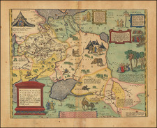
An Early Mapping of the Bukovina District
Finely executed map of of the Bukovina District, shortly before it became a formal district of the Kingdom of Galicia and Lodomeria in 1787.
The map shows the Bukovina District, also known as the Chernivtsi District, a former administrative-territorial unit of the Kingdom of Galicia and Lodomeria. The district was within the Habsburg monarchy, which was annexed from Moldavia.
Bukovina was the was first a military district from 1775 to 1786 until it was officially incorporated into Galicia and Lodomeria as its own district.
The first Austrian Empire occupied Bukovina in October 1774. After the First Partition of Poland in 1772, the Austrians claimed Bukovina to establish a road between Galicia and Transylvania. Bukovina was formally annexed by the Austrian Empire in January 1775. Bukovina remained a part of the Austrian constituent Kingdom of Galicia and Lodomeria from 1787 to 1849.
![[Lithuania / Western Belarus] Partie De Lithuanie ou sont les Palatinats de Wilna et Troki, subdvises en leurs Chastellenies. et Parti du Palat.at de Minsk. . . . 1665](https://storage.googleapis.com/raremaps/img/small/76057.jpg)
![(Austria) Charte der Österreichischen Monarchie, nach den letzten Friedensschlüssen berichtigt. [Map of the Austrian Monarchy, corrected according to the latest peace treaties.]](https://storage.googleapis.com/raremaps/img/small/102892.jpg)
![Europe No. 16. Partie De La Russie D'Europe [Tambow, Woroniege, Saratow and Territoire De La Milice De Don, etc.]](https://storage.googleapis.com/raremaps/img/small/19823.jpg)