|
||

|

|
|

|
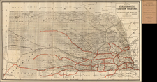
Creation of the Blackfeet Indian Reservation and Glacier Park -- Badger-Two Medicine
Finely detailed blue print map of a part of Northwestern Montana, primarily showing the boundaries of the Blackfeet Reservation at the time of its creation and the arrival of the Northern Pacific Railroad in about 1895-1896.
The map provides early topographical details, along with roads and the lines of the Great Northern Railroad. Beginning with MacDonald Lake in the west, the map makes a meticulous study of the region, focusing on mountains, creeks, wagon roads, ranches, heavy timber areas, trails, etc. The notes on the map are primarily focused on the quality of the roads, grades, availability of grass and water, and similar details.
One note at the center states "An old road said to yet exist (1894)" gives a clue to the dating of the map.
Some of the longer notes state:
- Roads in the Dominion are generally well watered, - fuel only found in mountains and near the larger streams,- Streams generally accessible and fordable
- On going to St. Marys Lakes with wagons Fr. Blackfoot-one can make a camp on Mid Fork of Milk Riv. about 27 mi. fr. Blackfoot and then make Norris Cabin next day 20 mi. fr. camp. With Packs alone, go by way of Billedoux or Birds Ranch - about 30 mi. this way, on the wagon road to Norris the last 9 mi. is bad - chuck holes and hilly difficult to carry over 3000 lbs. in a 6 mule wagon.
- There is a good wagon road from Cut Bank to Blackfoot more or less hilly-sandy, plenty of grass along road. Several small lakes which have water in them the greater part of the summer-road about 300 yards south of road track, open country no timber
- The St. Marys Lake Country can be reached by wagons to lower Lake, Packs required above. Mountains very rough. and heavily timbered, Creeks full of trout, Ducks, Grouse and large game abound.
- Road from Bear Creek to Essex good to 1 mi west of Java, on left side and about 100 to 300 yds, fr track thro. timber road dirt, plenty water and grass road follows creek which is between road and track, at Java cross to right, then road is impracticable is on side hill and covered with slides, rock and timber.
- Road From Summit to Bear Creek Fair is hilly and sandy-crosses track several times to about 2 mi, west of Summit then runs along south side plenty water and grazing as there is a small creek all the way down to Bear Creek. Road generally sandy and gravel dis. fr. 50 yards to 1/4 mile from track mostly open-small timber for fuel.
- Water of streams between St. Marys and Cut Bank Rivers and between Willow Creek and the Main Divide are usually alkaline
- 9 mi.fr. Rock Springs 130 mi. to Assinniboine (about) Running water - Alkaline water sometimes in holes
- Old Piegan Agency abandoned 1894 Good camp-wood water-grass- trout-grouse. 21 mi. fr. Birch Greek crossing 15 mi fr. Black foot Station.
Based upon the information shown on the map, we date the creation of the map to be in 1894 or shortly thereafter. The following milestones are relevant:
- 1892 First Boarding school for the Blackfeet opens at Willow Creek, west of present-day Browning. (Agency School, shown on map)
- 1893 Completion of the Great Northern Transcontinental Railroad through Blackfeet country. (shown on map)
- 1894 Town of Browning was established on the Blackfeet Reservation. (townsite shown, but unnamed)
- 1895 Blackfeet Indian Agency Headquarters opens in the new town of Browning. (shown on map between Durham and Blackfoot)
- 1896 Blackfeet sell the land that is to become Glacier National Park for the sum of $1,500,00 (Glacier Park not shown)
- 1899 U.S. Post Office at Durham relocated to Browning. (not shown)
Among the early landmarks on the map are:
- Roman Catholic Mission ( Holy Family Mission opened in 1890 on the Two Medicine River)
- Old Piegan Agency (1880-1894)
- Billedoux (Billedeaux) Ranch
- Birds Ranch
- Upton's Ranch
- Hinkle Cabin
- Norris Cabin
Blackfeet Nation and Reservation
The Blackfeet tribe migrated to the Montana region in the 17th century. They were forced to leave their original habitats, the woodlands north and west of the Great Lakes, due to pressure from British traders in James Bay, now part of modern-day Canada. This led the Blackfeet tribe to move towards the Northern Plains, where they would gain possession of firearms and horses, thus solidifying their status as a formidable force. At the height of their influence, the tribe's territory stretched from present-day Edmonton, Alberta Province, nearly to Yellowstone National Park, and from Glacier Park to the Black Hills of South Dakota. The Badger-Two Medicine area holds significant spiritual value for the tribe.
Towards the end of the 19th century, the encroachment of European Americans and Canadians forced the Blackfeet tribe to relinquish vast swaths of their land, leading them to relocate to smaller Indian reservations in the United States and reserves in Canada. Established by the Treaty of 1896, the Blackfeet reservation is situated adjacent to two federally governed regions: the Lewis and Clark National Forest, established in 1896, and Glacier National Park, both previously forming part of the tribal nation's territory. The Badger-Two Medicine area, a sacred 200 square mile area within the Lewis and Clark National Forest, was excluded from the Blackfeet lands under the Treaty of 1896, though the tribe maintained access, hunting, and fishing rights.
In the mid-19th century, military mapping of the region that includes the Blackfeet Indian Reservation became an important part of U.S. expansion efforts. The Department of the Dakota played a significant role in this process. The Department of the Dakota was a military command territory established in 1866. It comprised all the land from the Mississippi River to the Rocky Mountains and the Canadian border to Kansas. Under the command of General Alfred H. Terry, it was responsible for protecting frontier settlements, maintaining peace with the Native American tribes, and securing safe passage for settlers moving west.
Understanding the topography and tribal territories was crucial for the execution of these responsibilities. Hence, the Department of the Dakota initiated comprehensive mapping activities. Their cartographers and surveyors, often accompanied by military escorts, ventured into the field to gather the required data. They meticulously sketched river systems, mountain ranges, plains, and existing trail networks.
When it came to mapping the region occupied by the Blackfeet Tribe, military cartographers faced a considerable challenge. The region was vast, covering parts of present-day Montana, Idaho, and Wyoming, with diverse geographic features ranging from the Great Plains to the Rocky Mountains. The Blackfeet were known for their fierce resistance to encroachment onto their lands, which further complicated the task.
These military maps of the Blackfeet Indian Reservation also had long-term implications. They provided the first detailed records of the region, forming the foundation for future topographical and geological studies. The maps also became a tool for policy-making, aiding in decisions about reservations, resource allocation, and infrastructure development in the area.
Rarity
The map is unrecorded.
Blueprint & Blue Line maps (Cyanotype Printing)
Blueprint and blue line maps were among the most popular means for the swift printing of maps for which there would be a limited demand. A blueprint or blue line map could be made and/or revised much more quickly than a lithograph, cerograph, or other printing method, and at a much lower cost.
This method of printing was invented in 1842 by John Herschel, a chemist, astronomer, and photographer. A cyanotype process, one starts by drawing on semi-transparent paper, weighted down by a top sheet of paper. The paper would be coated with a photosensitive chemical mixture of potassium ferricyanogen and ferric ammonium citrate. The paper would then be exposed to light, wherein the exposed portions turned blue and the drawn lines, protected from exposure, would remain white.
The cyanotype printing process was an improvement on the expensive and time-consuming method of hand-tracing original documents. The technique was particularly popular with architects; by the 1890s, a blueprint was one-tenth the cost of a hand-traced reproduction. It could also be copied more quickly.
Blueprint and blue line maps began to appear as early as the 1850s and 1860s, but they really began to become the standard for mining and similar limited-purpose maps by the 1880s. The ability to create these maps quickly and at a low cost made them the standard for short-run prints, ideal for mapping mining regions in the West and for similar purposes.
The method still exists today, but in a very limited fashion. In the 1940s, diazo prints (whiteprints or bluelines) became more popular, as they were easier to read and faster to make. The blue lines on a white background of these prints are now what most people call blueprints.
![[ Idaho Below Montana ] Verein-Staaten am Stillen Ocean… [inset of San Francisco Bay] [Unusual Idaho & California configurations]](https://storage.googleapis.com/raremaps/img/small/99297.jpg)
![Map of Oregon, Washington and Part of Idaho [First Appearance Of Idaho Territory, including western Montana and Western Wyoming]](https://storage.googleapis.com/raremaps/img/small/94211.jpg)