


|
||

|

|
|

|
Stock# 90723
Description
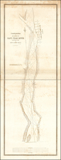
Fine large sea chart of the coast of North Carolina around Cape Hatteras, extending from Portsmouth Island and Ocracoke Inlet to Avon, published by the U.S. Coast & Geodetic Survey.
Includes extensive soundings, topographical features and the details around Hatteras Inlet and Ocracoke Inlet.
The chart shows a number of lights, buoys, the Telegraph Signal Station at Cape Hatteras, Durant's Life Saving Station, Ocracoke Life Saving Station.
Includes extensive annotations from an early user.
Condition Description
Blue backed chart. Minor soiling. Pencil and pen notes.
![[First State?] Rand, McNally & Co's Indexed County Map of North Carolina . . . 1880](https://storage.googleapis.com/raremaps/img/small/87572.jpg)

![[Untitled Coast chart of North Carolina, South Carolina, Georgia, and Florida, with insets of the harbor of Charleston, S.C. and the entrance of the Saint Johns River]](https://storage.googleapis.com/raremaps/img/small/91737.jpg)