This item has been sold, but you can enter your email address to be notified if another example becomes available.


|
||

|

|
|

|
Stock# 90719
Description
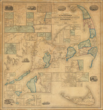
Highly detailed chart showing Nantucket Island and environs, extending north to Muskeget Channel.
This separately issued chart was intended for use for navigation and it contains all navigational information necessary for a ship's captain. Soundings and other navigational details are precisely depicted throughout the map. Interior information is shown in a narrow band along the Massachusetts' coast and for the entire interior of the island.