|
||

|

|
|

|
Stock# 70735
Description
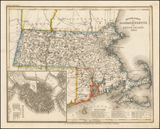
An Iconic Cape Cod -- Nantucket - Martha's Vineyard Wall Map
Nice example of this remarkable wall map of the area around Cape Cod, Nantucket and Martha's Vineyard, one of the largest ever produced for the region.
The views on the map include Provincetown Harbor 1620, Provincetown Harbor 1808, Main Street in Barnstable and 2 others. The town plans include Nantucket, Barnstable Village, Yarmouth Village, Hyannis, Hyannis Port, and Provincetown Village.
The map is colored by townships and provides remarkable detail, with numerous insets of towns and views of important landmarks.
Condition Description
Wall map with minor restorations. Old linen is supported with a thin new linen. Usual evidence of soiling, toning, staining and chipping, but generally in nice condition. The rods have been removed.
![[ Temperance Allegorical View ] Black Valley Railroad. Tickets Sold at all Liquor Shops. Accidents by Collisions are Entirely Avoided, as no up Trains are Run Over the Road.](https://storage.googleapis.com/raremaps/img/small/101469.jpg)
![[Plymouth Bay, Cape Cod Bay, Duxbury Bay]](https://storage.googleapis.com/raremaps/img/small/51249.jpg)
![[ Revolutionary War Boston ] Carte Particuliere Du Havre De Boston . . . 1780](https://storage.googleapis.com/raremaps/img/small/61227.jpg)