
This item has been sold, but you can enter your email address to be notified if another example becomes available.


|
||

|

|
|

|
Stock# 90698
Description
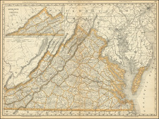
Detailed nautical chart of the mouth of the Chesapeake, published by the US Coast & Geodetic Survey.
The persent example was issued in 1877, with minor navigational improvements to 1885.
The map covers Norfolk, Virginia Beach , Newport News, Hampton, the mouth of the York River and the Cape Charles area.
Extensive sailing directions, soundings, etc.
Condition Description
Blue backed chart with minor soiling and evidence of use.
![[ Florida Native Americans -- Idol Worship ] Idolum Kiwasa XXI](https://storage.googleapis.com/raremaps/img/small/98017.jpg)
![A New Map of Virginia [Chesapeake]](https://storage.googleapis.com/raremaps/img/small/43053.jpg)