


|
||

|

|
|

|
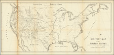
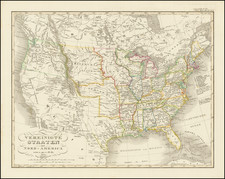
Fascinating Government Map of the United States
Interesting map of the United States, focusing on the Military Forts and Military Districts in the United States.
Shows also the "Extreme Line of Outposts in 1845" and several major roads to the west. The various military Departments are also named. Includes a number of short lived forts west of the Mississippi.
The map notes Lieutenant Mowry's Route to Los Angeles. This would be Liuetenant Sylvester Mowry (1833-1871) and John Chandler's expedition from the Great Salt Lake to Fort Tejon in 1855. Mowry, a West Point graduate, is most famous as an early advocate for the establishment of the Arizona Territory, who was later arrested as a traitor during the American Civil War. After graduation from West Point, Mowry was assigned to the Pacific Railroad Survey near the Columbia River, serving under Isaac Ingalls Stevens. During the winter of 1854–55 he served under Lieutenant Colonel Edward Steptoe in Utah, during which time Mowry seduced the married niece of Brigham Young, which resulted in his hastily being ordered to lead an expedition from the Great Salt Lake through the Great Basin to Fort Tejon, California.
![(Lasalle's Final Expedition) Dernieres Decouvertes dans L'Amerique Septentrionale de M. De La Sale [i.e., La Salle], Mises au jour par M. le Chevalier Tonti, Gouverneur du Fort Saint Louis, aux Islinois.](https://storage.googleapis.com/raremaps/img/small/69476.jpg)